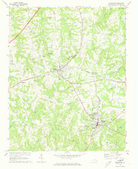
1970 Map of Warrenton
USGS Topo · Published 1973About this map
Norlina and Warrenton serve as the primary hubs of this Warren County landscape, connected by the branching tracks of the Seaboard Coast Line. This region is characterized by a high density of rural religious and civic centers, from Good Shepherd Ch near Ridgeway to St Pauls Ch in the west. The topography is defined by the headwaters of numerous creeks, including Fishing Creek and Hawtree Creek, which carve a rolling terrain between the small settlements. Local history is deeply etched into the land through family and community landmarks like Whites Grove Cem and Warren Dale Cem. The presence of the State Correctional Unit and the Hawkins Sch south of the county seat reflects the institutional growth in the area by 1970. Significant community gathering places such as Camp Katzenstein and the Armory in Warrenton highlight the social fabric of the era.
Find a feature on this map
51 named features on this map. Tap any name to fly to it.
Don’t see what you’re looking for? This feature index may not catch every label — zoom into the map to look around manually.
Map Details
Editions of this 1970 Warrenton Map
This is the sole edition of this map. No revisions or reprints were ever made.
Other maps of this area

1953 · Greensboro
USGS Topo · 1:250,000

1954 · Greensboro
USGS Topo · 1:250,000

1955 · Boydton
USGS Topo · 1:62,500

1962 · Greensboro
USGS Topo · 1:250,000

1966 · Greensboro
USGS Topo · 1:250,000

1968 · South Hill SE
USGS Topo · 1:24,000

1968 · Bracey
USGS Topo · 1:24,000

1968 · John H Kerr Dam
USGS Topo · 1:24,000
1970 · Macon
USGS Topo · 1:24,000

1970 · Vicksboro
USGS Topo · 1:24,000