
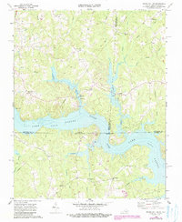
1968 Map of South Hill SE
USGS Topo · Published 1972About this map
Lake Gaston dominates this 1968 landscape, submerging the valley where the Roanoke River once flowed freely across the Virginia and North Carolina border. This map captures the region following the creation of the reservoir, highlighting the shift from a river-bottom economy to one centered on new shorelines and recreation, evidenced by several boat ramps and the Siouan Scout Reservation. Despite the rising waters, the upland areas maintain their traditional settlement patterns, anchored by numerous country churches such as St Stephens Ch, Rehobeth Ch, and Jordan Hill Ch. The Seaboard Coast Line railroad cuts through the northwest corner, serving rural communities like Barker Crossroads and Joyceville. This survey provides a precise record of the shoreline and the persisting road networks connecting Five Forks and other local crossroads during the late 1960s.
Find a feature on this map
35 named features on this map. Tap any name to fly to it.
Don’t see what you’re looking for? This feature index may not catch every label — zoom into the map to look around manually.
Map Details
Editions of this 1968 South Hill SE Map
3 editions found

Other maps of this area

1919 · White Plains
USGS Topo · 1:48,000

1920 · White Plains
USGS Topo · 1:62,500

1953 · Norfolk
USGS Topo · 1:250,000

1953 · Greensboro
USGS Topo · 1:250,000

1954 · Greensboro
USGS Topo · 1:250,000

1962 · Greensboro
USGS Topo · 1:250,000

1963 · Gasburg
USGS Topo · 1:24,000

1963 · White Plains
USGS Topo · 1:24,000

1966 · Greensboro
USGS Topo · 1:250,000

1968 · Bracey
USGS Topo · 1:24,000