
1968 Map of South Hill SE
USGS Topo · Published 1977About this map
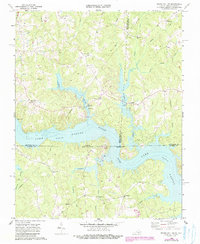
Lake Gaston dominates the central landscape of this border region, where the Roanoke River channel forms the boundary between Virginia and North Carolina. The map captures the area as it transitioned into a major recreational and residential hub, with several Boat Ramps and a Campground lining the northern shores near Joyceville. While the reservoir altered the natural drainage of tributaries like Miles Creek and Poplar Creek, the surrounding uplands retain a dense network of rural landmarks essential for genealogical research. Numerous country churches, including Bethel Grove Ch, St Stephens Ch, and Jordan Hill Ch, serve as anchors for the local communities. The western edge of the quadrangle is marked by the Seaboard Coast Line railroad, illustrating the historical transportation corridor that serviced the small settlements and crossroads like Barker Crossroads and Five Forks during the mid-to-late 20th century.
Find a feature on this map
36 named features on this map. Tap any name to fly to it.
Don’t see what you’re looking for? This feature index may not catch every label — zoom into the map to look around manually.
Map Details
Editions of this 1968 South Hill SE Map
3 editions found
Other maps of this area

1919 · White Plains
USGS Topo · 1:48,000

1920 · White Plains
USGS Topo · 1:62,500

1953 · Norfolk
USGS Topo · 1:250,000

1953 · Greensboro
USGS Topo · 1:250,000

1954 · Greensboro
USGS Topo · 1:250,000

1962 · Greensboro
USGS Topo · 1:250,000

1963 · Gasburg
USGS Topo · 1:24,000

1963 · White Plains
USGS Topo · 1:24,000

1966 · Greensboro
USGS Topo · 1:250,000

1968 · South Hill SE
USGS Topo · 1:24,000