1930s Maps of Sands, North Carolina
Explore 2 historic maps of Sands from the 1930s. These maps offer a rare glimpse into what life looked like during the 1930s — showing old roads, neighborhoods, homes, and landmarks that have changed or disappeared over time.
Whether you're researching your family's past, planning a metal detecting trip, or studying how Sands's landscape evolved across the 1930s, these high-resolution maps are a powerful tool for exploring the history of this region.
- Focus on a specific era: All maps on this page are from the 1930s, giving you a focused view of this time period.
- See what’s changed: Compare century-old streets, trails, and buildings to today's modern landscape using overlays and satellite layers.
- Research with precision: Use these maps for genealogy, historical research, land use analysis, or educational projects.
- View, download, or print: Maps are fully viewable online in high resolution, and can be downloaded or printed for your own records.
Start exploring Sands's history through authentic maps from the 1930s. This is your window into the past.
Sands, NC maps
(2)- 1935 Map of Zionville
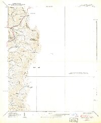
 1935 Zionville1935 Print · USGSThe Tennessee and North Carolina borderlands are captured here in the mid-1930s as high-country roads began to improve. Genealogists and hikers can trace old routes through the Gap of Rich Mtn or locate small settlements like Trade and Silverstone.
 - 1939 Map of Zionville
 1939 Zionville1939 Print · USGSThe North Carolina and Tennessee borderlands come alive in this late 1930s survey of the high mountain gaps. Genealogists can trace early homesteads near Zionville, Trade, and Greer Cem or find local landmarks like the Rich Mtn Sch.2 unique versions available
End of results
Showing maps 1-2 of 2
Top cities near Sands
- Boone historical maps
- Mountain City historical maps
- Jefferson historical maps
- Blowing Rock historical maps
- West Jefferson historical maps
- Banner Elk historical maps
See more
Frequently asked questions
- What are the different types of historical maps available for Sands?
- What is the oldest map of Sands?
- Where can I purchase historical maps of Sands for my home or office?
- Where can I download high-res historical maps of Sands?
- Are there historical topographic maps available for Sands?
- Is there historical aerial imagery available for Sands?
- Where are historical maps of Sands sourced from?