1940s Maps of Low Gap, North Carolina
Explore 2 historic maps of Low Gap from the 1940s. These maps offer a rare glimpse into what life looked like during the 1940s — showing old roads, neighborhoods, homes, and landmarks that have changed or disappeared over time.
Whether you're researching your family's past, planning a metal detecting trip, or studying how Low Gap's landscape evolved across the 1940s, these high-resolution maps are a powerful tool for exploring the history of this region.
- Focus on a specific era: All maps on this page are from the 1940s, giving you a focused view of this time period.
- See what’s changed: Compare century-old streets, trails, and buildings to today's modern landscape using overlays and satellite layers.
- Research with precision: Use these maps for genealogy, historical research, land use analysis, or educational projects.
- View, download, or print: Maps are fully viewable online in high resolution, and can be downloaded or printed for your own records.
Start exploring Low Gap's history through authentic maps from the 1940s. This is your window into the past.
Low Gap, NC maps
(2)- 1946 Map of Mt. Mitchell, 1957 Print
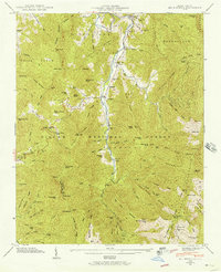 1946 Mt. Mitchell1957 Print · USGSThe high peaks of the Black Mountains are documented here just after the war, showing the early boundaries of Mount Mitchell State Park. Researchers can find family cemeteries like Ray Cem and Burleson Cem alongside the historic Murchison Ch.5 unique versions available
 - 1947 Map of Black Brothers
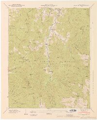 1947 Black Brothers1947 Print · USGSThe high peaks of the Black Mountains and the upper Cane River valley are shown here just after the war. Genealogists and hikers can trace old routes like the Toll Road, locate the Vixen (PO) post office, or find family plots at Penland Cem and Ivy Gap Cem.2 unique versions available
End of results
Showing maps 1-2 of 2
Top cities near Low Gap
- Asheville historical maps
- Weaverville historical maps
- Mars Hill historical maps
- Spruce Pine historical maps
- Burnsville historical maps
- Montreat historical maps
See more
Frequently asked questions
- What are the different types of historical maps available for Low Gap?
- What is the oldest map of Low Gap?
- Where can I purchase historical maps of Low Gap for my home or office?
- Where can I download high-res historical maps of Low Gap?
- Are there historical topographic maps available for Low Gap?
- Is there historical aerial imagery available for Low Gap?
- Where are historical maps of Low Gap sourced from?