1990s Maps of Garner Township, North Dakota
Explore 3 historic maps of Garner Township from the 1990s. These maps offer a rare glimpse into what life looked like during the 1990s — showing old roads, neighborhoods, homes, and landmarks that have changed or disappeared over time.
Whether you're researching your family's past, planning a metal detecting trip, or studying how Garner Township's landscape evolved across the 1990s, these high-resolution maps are a powerful tool for exploring the history of this region.
- Focus on a specific era: All maps on this page are from the 1990s, giving you a focused view of this time period.
- See what’s changed: Compare century-old streets, trails, and buildings to today's modern landscape using overlays and satellite layers.
- Research with precision: Use these maps for genealogy, historical research, land use analysis, or educational projects.
- View, download, or print: Maps are fully viewable online in high resolution, and can be downloaded or printed for your own records.
Start exploring Garner Township's history through authentic maps from the 1990s. This is your window into the past.
Garner Township, ND maps
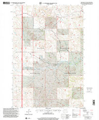
(3)- 1997 Map of Alpha, 2001 Print
 1997 Alpha2001 Print · USGSThe North Dakota Badlands near the turn of the millennium were a place of isolated ranches and vast grasslands. Researchers can locate legacy sites like the Randash Sch, the settlement of Alpha, and the family-held Remillong Ranch.
 - 1997 Map of Square Butte, 2001 Print
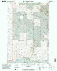
 1997 Square Butte2001 Print · USGSGolden Valley County in the late nineties is a landscape of rugged buttes and active energy production. Researchers can trace the ranching history of Olstad Ranch or locate infrastructure within the Square Butte Oil Field and the Little Missouri National Grassland.
 - 1997 Map of Dry Bullion Creek, 2001 Print
 1997 Dry Bullion Creek2001 Print · USGSExperience the rugged badlands of western North Dakota in the late 1990s, where public grazing lands meet the river. Genealogists and historians can locate isolated outposts like the Howard Ranch and Van Daele Ranch or trace the Little Missouri River.
End of results
Showing maps 1-3 of 3
Top cities near Garner Township
Frequently asked questions
- What are the different types of historical maps available for Garner Township?
- What is the oldest map of Garner Township?
- Where can I purchase historical maps of Garner Township for my home or office?
- Where can I download high-res historical maps of Garner Township?
- Are there historical topographic maps available for Garner Township?
- Is there historical aerial imagery available for Garner Township?
- Where are historical maps of Garner Township sourced from?