1960s Maps of Whitestone Hill Township, North Dakota
Explore 2 historic maps of Whitestone Hill Township from the 1960s. These maps offer a rare glimpse into what life looked like during the 1960s — showing old roads, neighborhoods, homes, and landmarks that have changed or disappeared over time.
Whether you're researching your family's past, planning a metal detecting trip, or studying how Whitestone Hill Township's landscape evolved across the 1960s, these high-resolution maps are a powerful tool for exploring the history of this region.
- Focus on a specific era: All maps on this page are from the 1960s, giving you a focused view of this time period.
- See what’s changed: Compare century-old streets, trails, and buildings to today's modern landscape using overlays and satellite layers.
- Research with precision: Use these maps for genealogy, historical research, land use analysis, or educational projects.
- View, download, or print: Maps are fully viewable online in high resolution, and can be downloaded or printed for your own records.
Start exploring Whitestone Hill Township's history through authentic maps from the 1960s. This is your window into the past.
Whitestone Hill Township, ND maps
(2)- 1962 Map of Lisbon SW, 1964 Print
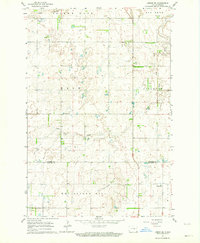 1962 Lisbon SW1964 Print · USGSRansom and Sargent counties are captured here in the early sixties, showing a landscape of scattered farmsteads and glacial hills. Genealogists can locate family sites near the Lutheran Ch, Cem, or along the banks of Dead Colt Creek.
 - 1962 Map of Gwinner, 1964 Print
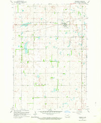 1962 Gwinner1964 Print · USGSSargent County in the early 1960s is captured at a point of industrial and agricultural transition. Genealogists and local historians can trace the early layout of Gwinner, the Northern Pacific rail line, and the location of Gwinner Cem.2 unique versions available
End of results
Showing maps 1-2 of 2
Top cities near Whitestone Hill Township
- Lisbon historical maps
- Gwinner historical maps
- Forman historical maps
- Rutland historical maps
- Cogswell historical maps
- Brampton Township historical maps
See more
Frequently asked questions
- What are the different types of historical maps available for Whitestone Hill Township?
- What is the oldest map of Whitestone Hill Township?
- Where can I purchase historical maps of Whitestone Hill Township for my home or office?
- Where can I download high-res historical maps of Whitestone Hill Township?
- Are there historical topographic maps available for Whitestone Hill Township?
- Is there historical aerial imagery available for Whitestone Hill Township?
- Where are historical maps of Whitestone Hill Township sourced from?