1990s Maps of Cherry Valley Township, Ohio
Explore 4 historic maps of Cherry Valley Township from the 1990s. These maps offer a rare glimpse into what life looked like during the 1990s — showing old roads, neighborhoods, homes, and landmarks that have changed or disappeared over time.
Whether you're researching your family's past, planning a metal detecting trip, or studying how Cherry Valley Township's landscape evolved across the 1990s, these high-resolution maps are a powerful tool for exploring the history of this region.
- Focus on a specific era: All maps on this page are from the 1990s, giving you a focused view of this time period.
- See what’s changed: Compare century-old streets, trails, and buildings to today's modern landscape using overlays and satellite layers.
- Research with precision: Use these maps for genealogy, historical research, land use analysis, or educational projects.
- View, download, or print: Maps are fully viewable online in high resolution, and can be downloaded or printed for your own records.
Start exploring Cherry Valley Township's history through authentic maps from the 1990s. This is your window into the past.
Cherry Valley Township, OH maps
(4)- 1994 Map of Dorset, 1997 Print
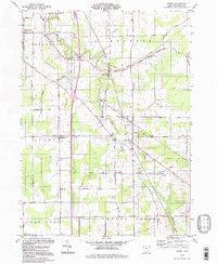 1994 Dorset1997 Print · USGSAshtabula County remained a landscape of quiet rural crossroads and family legacies in the 1990s. Genealogists can locate family burial sites like South Denmark Cem or trace the path of the Old Railroad Grade near Dorset.
 - 1994 Map of Andover, 1997 Print
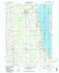 1994 Andover1997 Print · USGSAshtabula County and the Pennsylvania borderlands appear here in the mid-nineties, centered on the village of Andover. Researchers can trace family history through the West Lawn and Simons cemeteries or locate recreational landmarks like the Drive-in Theater.
 - 1994 Map of Cherry Valley, 1997 Print
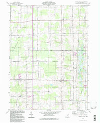 1994 Cherry Valley1997 Print · USGSAshtabula County remains a landscape of quiet crossroads and family-named roads in the mid-nineties. Researchers can locate ancestral sites like Cherry Valley Cem, the crossroads at Lebanon, or follow the waters of Pymatuning Creek and Mosquito Creek.
 - 1994 Map of Leon, 1997 Print
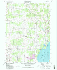 1994 Leon1997 Print · USGSThe Ohio-Pennsylvania borderlands near the turn of the millennium retain a deep rural character centered on the Ashtabula River headwaters. Genealogists and local historians can trace family sites at Pennline Cem, Richmond Center, and the small settlement of Leon.
End of results
Showing maps 1-4 of 4
Top cities near Cherry Valley Township
- Saybrook historical maps
- Jefferson Township historical maps
- Jefferson historical maps
- Bristol historical maps
- Mecca historical maps
- Mecca Township historical maps
See more
Top neighborhoods of Cherry Valley Township
Frequently asked questions
- What are the different types of historical maps available for Cherry Valley Township?
- What is the oldest map of Cherry Valley Township?
- Where can I purchase historical maps of Cherry Valley Township for my home or office?
- Where can I download high-res historical maps of Cherry Valley Township?
- Are there historical topographic maps available for Cherry Valley Township?
- Is there historical aerial imagery available for Cherry Valley Township?
- Where are historical maps of Cherry Valley Township sourced from?