1990s Maps of Batavia Township, Ohio
Explore 1 historic maps of Batavia Township from the 1990s. These maps offer a rare glimpse into what life looked like during the 1990s — showing old roads, neighborhoods, homes, and landmarks that have changed or disappeared over time.
Whether you're researching your family's past, planning a metal detecting trip, or studying how Batavia Township's landscape evolved across the 1990s, these high-resolution maps are a powerful tool for exploring the history of this region.
- Focus on a specific era: All maps on this page are from the 1990s, giving you a focused view of this time period.
- See what’s changed: Compare century-old streets, trails, and buildings to today's modern landscape using overlays and satellite layers.
- Research with precision: Use these maps for genealogy, historical research, land use analysis, or educational projects.
- View, download, or print: Maps are fully viewable online in high resolution, and can be downloaded or printed for your own records.
Start exploring Batavia Township's history through authentic maps from the 1990s. This is your window into the past.
Batavia Township, OH maps
(1)- 1996 Map of Batavia, 1999 Print
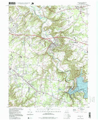 1996 Batavia1999 Print · USGSThe East Fork Little Miami River valley in the late twentieth century shows a landscape transitioning from rural townships to developed communities. Genealogists and local historians can locate Stonelick Cem, Amelia High Sch, and the old Drive-in Theater.
End of results
Showing maps 1-1 of 1
Top cities near Batavia Township
- Cincinnati historical maps
- Sharonville historical maps
- Loveland historical maps
- Blue Ash historical maps
- Montgomery historical maps
- Madeira historical maps
See more
Top neighborhoods of Batavia Township
- Braziers historical maps
- Olive Branch historical maps
- Hamlet historical maps
- East Batavia Heights historical maps
- Amelia historical maps
- Batavia historical maps
Frequently asked questions
- What are the different types of historical maps available for Batavia Township?
- What is the oldest map of Batavia Township?
- Where can I purchase historical maps of Batavia Township for my home or office?
- Where can I download high-res historical maps of Batavia Township?
- Are there historical topographic maps available for Batavia Township?
- Is there historical aerial imagery available for Batavia Township?
- Where are historical maps of Batavia Township sourced from?