1990s Maps of Union Township, Ohio
Explore 3 historic maps of Union Township from the 1990s. These maps offer a rare glimpse into what life looked like during the 1990s — showing old roads, neighborhoods, homes, and landmarks that have changed or disappeared over time.
Whether you're researching your family's past, planning a metal detecting trip, or studying how Union Township's landscape evolved across the 1990s, these high-resolution maps are a powerful tool for exploring the history of this region.
- Focus on a specific era: All maps on this page are from the 1990s, giving you a focused view of this time period.
- See what’s changed: Compare century-old streets, trails, and buildings to today's modern landscape using overlays and satellite layers.
- Research with precision: Use these maps for genealogy, historical research, land use analysis, or educational projects.
- View, download, or print: Maps are fully viewable online in high resolution, and can be downloaded or printed for your own records.
Start exploring Union Township's history through authentic maps from the 1990s. This is your window into the past.
Union Township, OH maps
(3)- 1996 Map of Madeira, 1999 Print
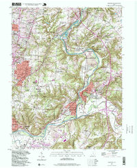 1996 Madeira1999 Print · USGSThe Little Miami River valley in the late nineties shows a landscape of established suburban communities and scenic river corridors. Trace family roots and local history through landmarks like Armstrong Chapel, Hopewell Cem, and Camp Dennison.
 - 1996 Map of Withamsvile, 1999 Print
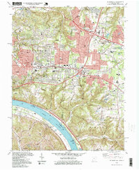 1996 Withamsvile1999 Print · USGSThe Ohio River valley and its growing suburban townships are captured here in the late 1990s as modern development reaches historical settlements. Researchers can trace the layout of St Gregorys Seminary, the Guardian Angel Cem, and the riverfront at Melbourne.
 - 1996 Map of Batavia, 1999 Print
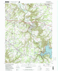 1996 Batavia1999 Print · USGSThe East Fork Little Miami River valley in the late twentieth century shows a landscape transitioning from rural townships to developed communities. Genealogists and local historians can locate Stonelick Cem, Amelia High Sch, and the old Drive-in Theater.
End of results
Showing maps 1-3 of 3
Top cities near Union Township
- Cincinnati historical maps
- Fairfield historical maps
- Covington historical maps
- Mason historical maps
- Independence historical maps
- Norwood historical maps
See more
Top neighborhoods of Union Township
- Romohr Acres historical maps
- South Milford historical maps
- Glen Este historical maps
- Summerside historical maps
- Hill Craft Acres historical maps
- Tobasco historical maps
See more
Frequently asked questions
- What are the different types of historical maps available for Union Township?
- What is the oldest map of Union Township?
- Where can I purchase historical maps of Union Township for my home or office?
- Where can I download high-res historical maps of Union Township?
- Are there historical topographic maps available for Union Township?
- Is there historical aerial imagery available for Union Township?
- Where are historical maps of Union Township sourced from?