1990s Maps of Lafayette Township, Ohio
Explore 6 historic maps of Lafayette Township from the 1990s. These maps offer a rare glimpse into what life looked like during the 1990s — showing old roads, neighborhoods, homes, and landmarks that have changed or disappeared over time.
Whether you're researching your family's past, planning a metal detecting trip, or studying how Lafayette Township's landscape evolved across the 1990s, these high-resolution maps are a powerful tool for exploring the history of this region.
- Focus on a specific era: All maps on this page are from the 1990s, giving you a focused view of this time period.
- See what’s changed: Compare century-old streets, trails, and buildings to today's modern landscape using overlays and satellite layers.
- Research with precision: Use these maps for genealogy, historical research, land use analysis, or educational projects.
- View, download, or print: Maps are fully viewable online in high resolution, and can be downloaded or printed for your own records.
Start exploring Lafayette Township's history through authentic maps from the 1990s. This is your window into the past.
Lafayette Township, OH maps
(6)- 1993 Map of Fresno
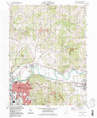
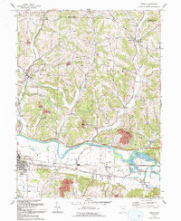 1993 Fresno1993 Print · USGSCentral Ohio at the start of the 1990s reveals a landscape defined by the Tuscarawas River and winding ridges. Genealogists can trace numerous family-named burial sites including Waggoner Cem, Clappboard Cem, and Kimble Cem.
 - 1993 Map of Plainfield
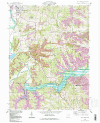
 1993 Plainfield1993 Print · USGSThe eastern Ohio borderlands of Coshocton and Guernsey counties appear here in the early nineties, centered on the complex shoreline of Wills Creek Lake. Researchers can locate several burial grounds like Schweitzer Cem and trace the paths of the Old RR Gr through Birds Run.
 - 1994 Map of Fresno, 1998 Print
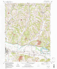 1994 Fresno1998 Print · USGSCoshocton County in the mid-1990s reveals a landscape of industrial strip mining and deep-rooted rural settlements along the Tuscarawas River. Genealogists can trace family names at numerous burial sites like Kimble Cem, Fairview Cem, and Woods College Cem.
 - 1994 Map of Plainfield, 1998 Print
 1994 Plainfield1998 Print · USGSEastern Ohio's river valleys and coal-rich hills are shown here in the 1990s as Wills Creek winds through the meeting point of three counties. Researchers can trace rural lineages through numerous local sites including Linton Mills, Plainfield Cem, and Birds Run.
 - 1994 Map of Wills Creek, 1998 Print
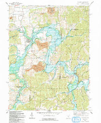
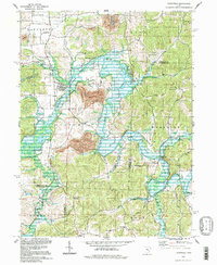
 1994 Wills Creek1998 Print · USGSThe Wills Creek valley was a hub of mining and water management in the late twentieth century. Genealogists and local researchers can trace the roads to Marquand Mills, Our Lady of Lourdes Ch, and the Wills Creek Dam.
 - 1994 Map of Coshocton, 1998 Print
 1994 Coshocton1998 Print · USGSThe rivers of Coshocton County meet in the late twentieth century as the industrial landscape and rural townships intersect. Genealogists can locate family landmarks like South Lawn Cemetery and Amity Cem or trace the old Canal Lewisville corridor.
End of results
Showing maps 1-6 of 6
Top cities near Lafayette Township
- Coshocton historical maps
- Cambridge historical maps
- Newcomerstown historical maps
- West Lafayette historical maps
- Keene historical maps
- Franklin historical maps
See more
Top neighborhoods of Lafayette Township
Frequently asked questions
- What are the different types of historical maps available for Lafayette Township?
- What is the oldest map of Lafayette Township?
- Where can I purchase historical maps of Lafayette Township for my home or office?
- Where can I download high-res historical maps of Lafayette Township?
- Are there historical topographic maps available for Lafayette Township?
- Is there historical aerial imagery available for Lafayette Township?
- Where are historical maps of Lafayette Township sourced from?