1940s Maps of Polk Township, Ohio
Explore 4 historic maps of Polk Township from the 1940s. These maps offer a rare glimpse into what life looked like during the 1940s — showing old roads, neighborhoods, homes, and landmarks that have changed or disappeared over time.
Whether you're researching your family's past, planning a metal detecting trip, or studying how Polk Township's landscape evolved across the 1940s, these high-resolution maps are a powerful tool for exploring the history of this region.
- Focus on a specific era: All maps on this page are from the 1940s, giving you a focused view of this time period.
- See what’s changed: Compare century-old streets, trails, and buildings to today's modern landscape using overlays and satellite layers.
- Research with precision: Use these maps for genealogy, historical research, land use analysis, or educational projects.
- View, download, or print: Maps are fully viewable online in high resolution, and can be downloaded or printed for your own records.
Start exploring Polk Township's history through authentic maps from the 1940s. This is your window into the past.
Polk Township, OH maps
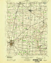
(4)- 1943 Map of Shauck
 1943 Shauck1943 Print · USGSNorth Central Ohio is captured here in the mid-1940s, showing a landscape of small agricultural hamlets and a dense network of country schools. Genealogists and researchers can trace local landmarks like Johnsville Shauck P O, Chestnut Chapel, and the Erie RR corridor.
 - 1943 Map of Bucyrus
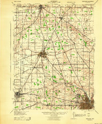
 1943 Bucyrus1943 Print · USGSCrawford County at the height of the Second World War reveals a landscape defined by busy rail junctions and rural school districts. Genealogists and historians can trace family roots through numerous numbered schoolhouses and settlements like Sulphur Springs, Tiro, and the County Infirmary.
 - 1943 Map of Crestline
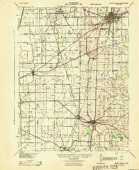
 1943 Crestline1943 Print · USGSNorth-central Ohio is seen at a mid-century industrial peak, dominated by the massive rail corridors of the PENNSYLVANIA and ERIE lines. Genealogists and historians can trace the rural landscape through dozens of numbered schoolhouses and small settlements like Planktown, Ganges, and Toledo Jc.2 unique versions available
 - 1943 Map of Mount Gilead
 1943 Mount Gilead1943 Print · USGSIn the early 1940s, this pocket of north-central Ohio remained a landscape of rail-connected towns and country school districts. Researchers can trace the rural heritage of Galion and Mount Gilead while locating landmarks like Miller Cem and the Guiding Star Sch.
End of results
Showing maps 1-4 of 4
Top cities near Polk Township
- Mansfield historical maps
- Bucyrus historical maps
- Galion historical maps
- Shelby historical maps
- Ontario historical maps
- Crestline historical maps
See more
Frequently asked questions
- What are the different types of historical maps available for Polk Township?
- What is the oldest map of Polk Township?
- Where can I purchase historical maps of Polk Township for my home or office?
- Where can I download high-res historical maps of Polk Township?
- Are there historical topographic maps available for Polk Township?
- Is there historical aerial imagery available for Polk Township?
- Where are historical maps of Polk Township sourced from?