1960s Maps of Schade-Mylander Plaza, Sandusky
Explore 2 historic maps of Schade-Mylander Plaza from the 1960s. These maps offer a rare glimpse into what life looked like during the 1960s — showing old roads, neighborhoods, homes, and landmarks that have changed or disappeared over time.
Whether you're researching your family's past, planning a metal detecting trip, or studying how Schade-Mylander Plaza's landscape evolved across the 1960s, these high-resolution maps are a powerful tool for exploring the history of this region.
- Focus on a specific era: All maps on this page are from the 1960s, giving you a focused view of this time period.
- See what’s changed: Compare century-old streets, trails, and buildings to today's modern landscape using overlays and satellite layers.
- Research with precision: Use these maps for genealogy, historical research, land use analysis, or educational projects.
- View, download, or print: Maps are fully viewable online in high resolution, and can be downloaded or printed for your own records.
Start exploring Schade-Mylander Plaza's history through authentic maps from the 1960s. This is your window into the past.
Schade-Mylander Plaza, Sandusky maps
(2)- 1961 Map of Toledo
 1961 Toledo1961 Print · USGSThe western basin of Lake Erie and the industrial heart of Northern Ohio are captured here during the post-war era. Researchers can trace historical rail lines like the New York Central or locate landmarks like the Erie Ordnance Depot and Pelee Island.
 - 1969 Map of Sandusky, 1971 Print
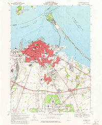 1969 Sandusky1971 Print · USGSSandusky and the Lake Erie shoreline are shown here in the late sixties, just as the region’s aerospace and tourism sectors were peaking. Trace local roots through a dense network of parish schools and burial grounds like St Josephs Cem or locate the sprawling NASA Lewis Research Center.5 unique versions available
End of results
Showing maps 1-2 of 2
Frequently asked questions
- What are the different types of historical maps available for Schade-Mylander Plaza?
- What is the oldest map of Schade-Mylander Plaza?
- Where can I purchase historical maps of Schade-Mylander Plaza for my home or office?
- Where can I download high-res historical maps of Schade-Mylander Plaza?
- Are there historical topographic maps available for Schade-Mylander Plaza?
- Is there historical aerial imagery available for Schade-Mylander Plaza?
- Where are historical maps of Schade-Mylander Plaza sourced from?