1960s Maps of Fostoria, Ohio
Explore 3 historic maps of Fostoria from the 1960s. These maps offer a rare glimpse into what life looked like during the 1960s — showing old roads, neighborhoods, homes, and landmarks that have changed or disappeared over time.
Whether you're researching your family's past, planning a metal detecting trip, or studying how Fostoria's landscape evolved across the 1960s, these high-resolution maps are a powerful tool for exploring the history of this region.
- Focus on a specific era: All maps on this page are from the 1960s, giving you a focused view of this time period.
- See what’s changed: Compare century-old streets, trails, and buildings to today's modern landscape using overlays and satellite layers.
- Research with precision: Use these maps for genealogy, historical research, land use analysis, or educational projects.
- View, download, or print: Maps are fully viewable online in high resolution, and can be downloaded or printed for your own records.
Start exploring Fostoria's history through authentic maps from the 1960s. This is your window into the past.
Fostoria, OH maps
(3)- 1960 Map of Bascom, 1961 Print
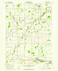 1960 Bascom1961 Print · USGSSeneca County's agricultural heartland was a busy corridor for the Baltimore and Ohio and Nickel Plate railroads at the start of the 1960s. Genealogists can locate family landmarks like Null Cem, Zion Ch, and the rural Iler (Ilers Sta).2 unique versions available
 - 1960 Map of Fostoria, 1961 Print
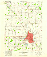 1960 Fostoria1961 Print · USGSFostoria is captured at the height of its mid-century industrial prominence, serving as a vital crossroads for four major railroads. Genealogists and local historians can trace the city's growth alongside rural landmarks like Dysinger Cem, Field Sch, and Lake Lamberjack.2 unique versions available
 - 1961 Map of Toledo
 1961 Toledo1961 Print · USGSThe western basin of Lake Erie and the industrial heart of Northern Ohio are captured here during the post-war era. Researchers can trace historical rail lines like the New York Central or locate landmarks like the Erie Ordnance Depot and Pelee Island.
End of results
Showing maps 1-3 of 3
Top cities near Fostoria
- Findlay historical maps
- Bowling Green historical maps
- Tiffin historical maps
- Carey historical maps
- Gibsonburg historical maps
- Tymochtee historical maps
See more
Top neighborhoods of Fostoria
- North Pointe Place Mobile Home Park historical maps
- Nyes Mobile Home Park historical maps
- Downtown Fostoria historical maps
- Westgate Village historical maps
Frequently asked questions
- What are the different types of historical maps available for Fostoria?
- What is the oldest map of Fostoria?
- Where can I purchase historical maps of Fostoria for my home or office?
- Where can I download high-res historical maps of Fostoria?
- Are there historical topographic maps available for Fostoria?
- Is there historical aerial imagery available for Fostoria?
- Where are historical maps of Fostoria sourced from?