1970s Maps of Cora, Perry Township
Explore 1 historic maps of Cora from the 1970s. These maps offer a rare glimpse into what life looked like during the 1970s — showing old roads, neighborhoods, homes, and landmarks that have changed or disappeared over time.
Whether you're researching your family's past, planning a metal detecting trip, or studying how Cora's landscape evolved across the 1970s, these high-resolution maps are a powerful tool for exploring the history of this region.
- Focus on a specific era: All maps on this page are from the 1970s, giving you a focused view of this time period.
- See what’s changed: Compare century-old streets, trails, and buildings to today's modern landscape using overlays and satellite layers.
- Research with precision: Use these maps for genealogy, historical research, land use analysis, or educational projects.
- View, download, or print: Maps are fully viewable online in high resolution, and can be downloaded or printed for your own records.
Start exploring Cora's history through authentic maps from the 1970s. This is your window into the past.
Cora, Perry Township maps
(1)- 1975 Map of Rodney, 1977 Print
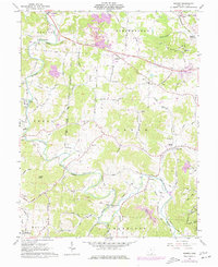 1975 Rodney1977 Print · USGSThe winding waters of Raccoon Creek define the Gallia County countryside in the mid-1970s. Local historians can trace old community hubs at Adamsville, Cora, and Rodney, alongside family burial grounds like Hulbert Cem and Ouster Cem.
End of results
Showing maps 1-1 of 1
Top cities near Cora
- Point Pleasant historical maps
- Gallipolis historical maps
- Addison historical maps
- Oak Hill historical maps
- Rio Grande historical maps
- Vinton historical maps
Frequently asked questions
- What are the different types of historical maps available for Cora?
- What is the oldest map of Cora?
- Where can I purchase historical maps of Cora for my home or office?
- Where can I download high-res historical maps of Cora?
- Are there historical topographic maps available for Cora?
- Is there historical aerial imagery available for Cora?
- Where are historical maps of Cora sourced from?