1950s Maps of Munson Township, Ohio
Explore 6 historic maps of Munson Township from the 1950s. These maps offer a rare glimpse into what life looked like during the 1950s — showing old roads, neighborhoods, homes, and landmarks that have changed or disappeared over time.
Whether you're researching your family's past, planning a metal detecting trip, or studying how Munson Township's landscape evolved across the 1950s, these high-resolution maps are a powerful tool for exploring the history of this region.
- Focus on a specific era: All maps on this page are from the 1950s, giving you a focused view of this time period.
- See what’s changed: Compare century-old streets, trails, and buildings to today's modern landscape using overlays and satellite layers.
- Research with precision: Use these maps for genealogy, historical research, land use analysis, or educational projects.
- View, download, or print: Maps are fully viewable online in high resolution, and can be downloaded or printed for your own records.
Start exploring Munson Township's history through authentic maps from the 1950s. This is your window into the past.
Munson Township, OH maps
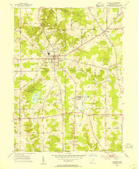
(6)- 1950 Map of Cleveland
 1950 Cleveland1950 Print · USGSCovers Munson Township, including Cleveland, Akron, and other nearby areas
 - 1953 Map of Chardon, 1954 Print
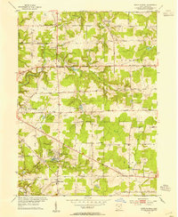
 1953 Chardon1954 Print · USGSMid-century Geauga County comes to life in this survey of the Connecticut Western Reserve during the early fifties. Local historians can locate the County Home, trace family names at Pitkin Cem, and see the early footprint of Chardon Airport.2 unique versions available
 - 1953 Map of South Russell, 1954 Print
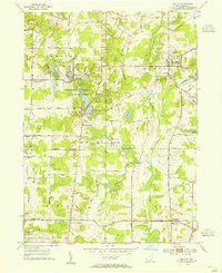
 1953 South Russell1954 Print · USGSGeauga County’s rolling landscape is shown here in the early fifties as the area began transitioning from rural farmsteads to suburban enclaves. Researchers can trace historic cemeteries and civic landmarks like Music Cem, Novelty P O, and the Chagrin Falls Airport.
 - 1953 Map of Burton, 1955 Print
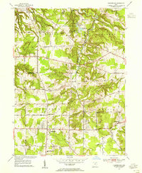
 1953 Burton1955 Print · USGSGeauga County is captured during a period of rural stability in the early fifties, centered on the village of Burton and the upper Cuyahoga River. Researchers can locate family landmarks like Welton Cem, St Helen Ch, and the sprawling Punderson Lake State Park.2 unique versions available
 - 1953 Map of Chesterland, 1955 Print
 1953 Chesterland1955 Print · USGSGeauga and Lake counties are shown here in the early fifties, featuring the established settlements of Chesterland and Kirtland. Genealogists can trace local roots through the Center Chardon Cem or find early industry at Fowlers Mill.
 - 1956 Map of Cleveland, 1967 Print
 1956 Cleveland1967 Print · USGSNortheast Ohio and Western Pennsylvania are shown at their industrial height during the mid-fifties, from the steel mills to the lakeshore. Researchers can trace the massive Ravenna Arsenal, the Ohio Turnpike, and vanished rail sidings of the B & O RR.3 unique versions available
End of results
Showing maps 1-6 of 6
Top cities near Munson Township
- Mentor historical maps
- Solon historical maps
- Willoughby historical maps
- Painesville historical maps
- Mayfield Heights historical maps
- Twinsburg historical maps
See more
Top neighborhoods of Munson Township
Frequently asked questions
- What are the different types of historical maps available for Munson Township?
- What is the oldest map of Munson Township?
- Where can I purchase historical maps of Munson Township for my home or office?
- Where can I download high-res historical maps of Munson Township?
- Are there historical topographic maps available for Munson Township?
- Is there historical aerial imagery available for Munson Township?
- Where are historical maps of Munson Township sourced from?