1990s Maps of Oreville, Ohio
Explore 1 historic maps of Oreville from the 1990s. These maps offer a rare glimpse into what life looked like during the 1990s — showing old roads, neighborhoods, homes, and landmarks that have changed or disappeared over time.
Whether you're researching your family's past, planning a metal detecting trip, or studying how Oreville's landscape evolved across the 1990s, these high-resolution maps are a powerful tool for exploring the history of this region.
- Focus on a specific era: All maps on this page are from the 1990s, giving you a focused view of this time period.
- See what’s changed: Compare century-old streets, trails, and buildings to today's modern landscape using overlays and satellite layers.
- Research with precision: Use these maps for genealogy, historical research, land use analysis, or educational projects.
- View, download, or print: Maps are fully viewable online in high resolution, and can be downloaded or printed for your own records.
Start exploring Oreville's history through authentic maps from the 1990s. This is your window into the past.
Oreville, OH maps
(1)- 1992 Map of Gore, 1995 Print
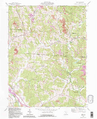 1992 Gore1995 Print · USGSHocking and Perry counties appear here during the early nineties, showcasing a terrain defined by industrial rail lines and deep forest. Genealogists can trace family names at Webb Chapel Cem or locate the historic iron works at Bessie Furnace and Sand Run Junction.
End of results
Showing maps 1-1 of 1
Top cities near Oreville
- Athens historical maps
- Nelsonville historical maps
- New Lexington historical maps
- The Plains historical maps
- Crooksville historical maps
- Glouster historical maps
See more
Frequently asked questions
- What are the different types of historical maps available for Oreville?
- What is the oldest map of Oreville?
- Where can I purchase historical maps of Oreville for my home or office?
- Where can I download high-res historical maps of Oreville?
- Are there historical topographic maps available for Oreville?
- Is there historical aerial imagery available for Oreville?
- Where are historical maps of Oreville sourced from?