1950s Maps of Powerstown, Youngstown
Explore 4 historic maps of Powerstown from the 1950s. These maps offer a rare glimpse into what life looked like during the 1950s — showing old roads, neighborhoods, homes, and landmarks that have changed or disappeared over time.
Whether you're researching your family's past, planning a metal detecting trip, or studying how Powerstown's landscape evolved across the 1950s, these high-resolution maps are a powerful tool for exploring the history of this region.
- Focus on a specific era: All maps on this page are from the 1950s, giving you a focused view of this time period.
- See what’s changed: Compare century-old streets, trails, and buildings to today's modern landscape using overlays and satellite layers.
- Research with precision: Use these maps for genealogy, historical research, land use analysis, or educational projects.
- View, download, or print: Maps are fully viewable online in high resolution, and can be downloaded or printed for your own records.
Start exploring Powerstown's history through authentic maps from the 1950s. This is your window into the past.
Powerstown, Youngstown maps
(4)- 1950 Map of Cleveland
 1950 Cleveland1950 Print · USGSCovers Powerstown, including Cleveland, Akron, and other nearby areas
 - 1951 Map of Campbell, 1953 Print
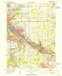 1951 Campbell1953 Print · USGSThe Mahoning River valley in the early fifties shows a dense industrial corridor of rails and riverside towns on the Ohio-Pennsylvania line. Genealogists can trace family landmarks like White Sch, St Johns Cem, and Holy Rosary Cem.
 - 1951 Map of Youngstown, 1953 Print
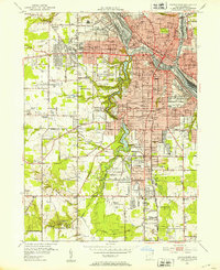 1951 Youngstown1953 Print · USGSYoungstown at the peak of its mid-century industrial era reveals a city defined by its river-valley railroads and sprawling park systems. Researchers can trace neighborhood history through landmarks like Idora Park, Youngstown College, and the sprawling Mill Creek Park.
 - 1956 Map of Cleveland, 1967 Print
 1956 Cleveland1967 Print · USGSNortheast Ohio and Western Pennsylvania are shown at their industrial height during the mid-fifties, from the steel mills to the lakeshore. Researchers can trace the massive Ravenna Arsenal, the Ohio Turnpike, and vanished rail sidings of the B & O RR.3 unique versions available
End of results
Showing maps 1-4 of 4
Frequently asked questions
- What are the different types of historical maps available for Powerstown?
- What is the oldest map of Powerstown?
- Where can I purchase historical maps of Powerstown for my home or office?
- Where can I download high-res historical maps of Powerstown?
- Are there historical topographic maps available for Powerstown?
- Is there historical aerial imagery available for Powerstown?
- Where are historical maps of Powerstown sourced from?