1960s Maps of Covington, Ohio
Explore 2 historic maps of Covington from the 1960s. These maps offer a rare glimpse into what life looked like during the 1960s — showing old roads, neighborhoods, homes, and landmarks that have changed or disappeared over time.
Whether you're researching your family's past, planning a metal detecting trip, or studying how Covington's landscape evolved across the 1960s, these high-resolution maps are a powerful tool for exploring the history of this region.
- Focus on a specific era: All maps on this page are from the 1960s, giving you a focused view of this time period.
- See what’s changed: Compare century-old streets, trails, and buildings to today's modern landscape using overlays and satellite layers.
- Research with precision: Use these maps for genealogy, historical research, land use analysis, or educational projects.
- View, download, or print: Maps are fully viewable online in high resolution, and can be downloaded or printed for your own records.
Start exploring Covington's history through authentic maps from the 1960s. This is your window into the past.
Covington, OH maps
(2)- 1961 Map of Piqua West, 1962 Print
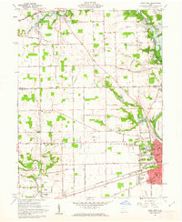 1961 Piqua West1962 Print · USGSWestern Miami County is captured here in the early sixties as the suburbs of Piqua expanded toward Newberry and Washington townships. Researchers can trace family history through sites like Forest Hill Cemetery, St Teresas Ch, and the rural Mount Jefferson crossroads.4 unique versions available
 - 1961 Map of Pleasant Hill, 1962 Print
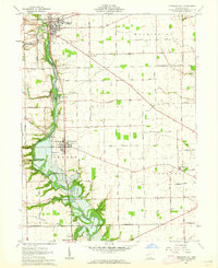 1961 Pleasant Hill1962 Print · USGSMiami County at the start of the sixties reveals a landscape of thriving river towns and established family farms. Researchers can trace the ancestral connections between Pleasant Hill and Covington or locate specific sites like the Concord Township Sch and Old Union Cem.2 unique versions available
End of results
Showing maps 1-2 of 2
Top cities near Covington
- Dayton historical maps
- Huber Heights historical maps
- Troy historical maps
- Piqua historical maps
- Sidney historical maps
- Vandalia historical maps
See more
Frequently asked questions
- What are the different types of historical maps available for Covington?
- What is the oldest map of Covington?
- Where can I purchase historical maps of Covington for my home or office?
- Where can I download high-res historical maps of Covington?
- Are there historical topographic maps available for Covington?
- Is there historical aerial imagery available for Covington?
- Where are historical maps of Covington sourced from?