1990s Maps of Benton Township, Ohio
Explore 4 historic maps of Benton Township from the 1990s. These maps offer a rare glimpse into what life looked like during the 1990s — showing old roads, neighborhoods, homes, and landmarks that have changed or disappeared over time.
Whether you're researching your family's past, planning a metal detecting trip, or studying how Benton Township's landscape evolved across the 1990s, these high-resolution maps are a powerful tool for exploring the history of this region.
- Focus on a specific era: All maps on this page are from the 1990s, giving you a focused view of this time period.
- See what’s changed: Compare century-old streets, trails, and buildings to today's modern landscape using overlays and satellite layers.
- Research with precision: Use these maps for genealogy, historical research, land use analysis, or educational projects.
- View, download, or print: Maps are fully viewable online in high resolution, and can be downloaded or printed for your own records.
Start exploring Benton Township's history through authentic maps from the 1990s. This is your window into the past.
Benton Township, OH maps
(4)- 1994 Map of Rinard Mills, 1998 Print
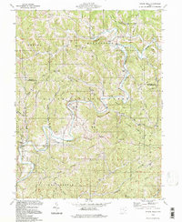 1994 Rinard Mills1998 Print · USGSThe Little Muskingum River valley of southeastern Ohio is shown here during the late twentieth century within the Wayne National Forest. Researchers can locate old congregations and family burial sites such as Merrell Ridge Ch, Cline Cem, and Bloomfield.
 - 1994 Map of Antioch, 1998 Print
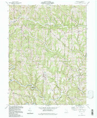 1994 Antioch1998 Print · USGSMonroe County, Ohio, remains defined by its deep ridges and the winding path of the Little Muskingum River during the late twentieth century. Genealogists can trace family landmarks and rural life through Moffets Ch, Haythorn Cem, and the settlement of Antioch.
 - 1994 Map of New Matamoras, 1998 Print
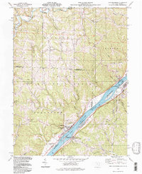 1994 New Matamoras1998 Print · USGSThe Ohio River corridor near New Matamoras and Sistersville is captured here in the 1990s, showing a river valley shaped by navigation and industry. Researchers can find old family landmarks and rural sites like Salem Hall, Yellow House, and Grandview Cem.
 - 1994 Map of Graysville, 1998 Print
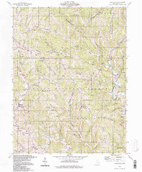 1994 Graysville1998 Print · USGSMonroe County’s ridge-and-hollow landscape is captured here in the 1990s, centered on the community of Graysville and the Wayne National Forest. Genealogists and historians can locate family landmarks like the Covered Bridge, Lamping Cem (Indian Mound), and Conner Ridge Ch.
End of results
Showing maps 1-4 of 4
Top cities near Benton Township
- New Martinsville historical maps
- Woodsfield historical maps
- Newport historical maps
- Grandview historical maps
- Sistersville historical maps
- Belmont historical maps
See more
Top neighborhoods of Benton Township
Frequently asked questions
- What are the different types of historical maps available for Benton Township?
- What is the oldest map of Benton Township?
- Where can I purchase historical maps of Benton Township for my home or office?
- Where can I download high-res historical maps of Benton Township?
- Are there historical topographic maps available for Benton Township?
- Is there historical aerial imagery available for Benton Township?
- Where are historical maps of Benton Township sourced from?