1990s Maps of Franklin Township, Ohio
Explore 4 historic maps of Franklin Township from the 1990s. These maps offer a rare glimpse into what life looked like during the 1990s — showing old roads, neighborhoods, homes, and landmarks that have changed or disappeared over time.
Whether you're researching your family's past, planning a metal detecting trip, or studying how Franklin Township's landscape evolved across the 1990s, these high-resolution maps are a powerful tool for exploring the history of this region.
- Focus on a specific era: All maps on this page are from the 1990s, giving you a focused view of this time period.
- See what’s changed: Compare century-old streets, trails, and buildings to today's modern landscape using overlays and satellite layers.
- Research with precision: Use these maps for genealogy, historical research, land use analysis, or educational projects.
- View, download, or print: Maps are fully viewable online in high resolution, and can be downloaded or printed for your own records.
Start exploring Franklin Township's history through authentic maps from the 1990s. This is your window into the past.
Franklin Township, OH maps
(4)- 1994 Map of Lewisville, 1998 Print
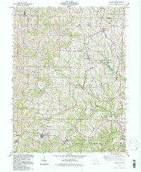 1994 Lewisville1998 Print · USGSMonroe County's rugged ridge-and-valley landscape is documented here in the 1990s, showing a region defined by rural settlements and early oil exploration. Researchers can trace ancestral locations from Lewisville to Malaga, or locate remote sites like the Free Burial Ground and St Johns Ch.
 - 1994 Map of Summerfield, 1998 Print
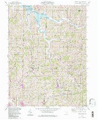 1994 Summerfield1998 Print · USGSSoutheastern Ohio's ridge country is beautifully detailed here in the mid-1990s, centering on the village of Summerfield and the waters of Senecaville Lake. Genealogists and hikers can locate numerous hillside burial grounds like Calais Cem and Bracken Cem, or trace the winding Little Muskingum River.
 - 1994 Map of Stafford, 1998 Print
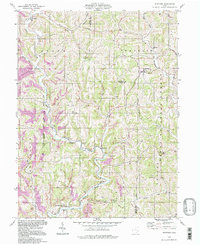 1994 Stafford1998 Print · USGSThe Noble and Monroe county borderlands appear in the mid-nineties as a landscape of deep valleys and forested ridges. Genealogists and historians can trace old homesteads and landmarks like Mt Tabor Ch, Township Sch, and the Zion Cem.
 - 1994 Map of Graysville, 1998 Print
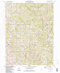 1994 Graysville1998 Print · USGSMonroe County’s ridge-and-hollow landscape is captured here in the 1990s, centered on the community of Graysville and the Wayne National Forest. Genealogists and historians can locate family landmarks like the Covered Bridge, Lamping Cem (Indian Mound), and Conner Ridge Ch.
End of results
Showing maps 1-4 of 4
Top cities near Franklin Township
- Woodsfield historical maps
- Grandview historical maps
- Malaga historical maps
- New Matamoras historical maps
- Senecaville historical maps
- Beallsville historical maps
See more
Top neighborhoods of Franklin Township
Frequently asked questions
- What are the different types of historical maps available for Franklin Township?
- What is the oldest map of Franklin Township?
- Where can I purchase historical maps of Franklin Township for my home or office?
- Where can I download high-res historical maps of Franklin Township?
- Are there historical topographic maps available for Franklin Township?
- Is there historical aerial imagery available for Franklin Township?
- Where are historical maps of Franklin Township sourced from?