1900s (20th Century) Maps of Bloomfield, Ohio
Explore 9 historic maps of Bloomfield from the 1900s (20th Century). These maps offer a rare glimpse into what life looked like during the 1900s — showing old roads, neighborhoods, homes, and landmarks that have changed or disappeared over time.
Whether you're researching your family's past, planning a metal detecting trip, or studying how Bloomfield's landscape evolved across the 1900s, these high-resolution maps are a powerful tool for exploring the history of this region.
- Focus on a specific era: All maps on this page are from the 1900s, giving you a focused view of this time period.
- See what’s changed: Compare century-old streets, trails, and buildings to today's modern landscape using overlays and satellite layers.
- Research with precision: Use these maps for genealogy, historical research, land use analysis, or educational projects.
- View, download, or print: Maps are fully viewable online in high resolution, and can be downloaded or printed for your own records.
Start exploring Bloomfield's history through authentic maps from the 1900s. This is your window into the past.
Bloomfield, OH maps
(9)- 1909 Map of Cambridge, 1963 Print
 1909 Cambridge1963 Print · USGSGuernsey County and the city of Cambridge are documented here in the early nineteen-hundreds, showing a region structured by river valleys and the historic National Road. Genealogists can trace early homesteads near Barnes Mill, the Galigher PO post office, and dozens of rural school sites.
 - 1912 Map of Cambridge, 1946 Print
 1912 Cambridge1946 Print · USGSGuernsey County was a bustling hub of rail and river commerce at the start of the century. You can trace the path of the National Road and locate family landmarks like Barnes Mill, Zion Church, and dozens of district schools.2 unique versions available
 - 1951 Map of Canton
 1951 Canton1951 Print · USGSThe industrial heartland of Ohio and Pennsylvania reached its mid-century peak during this era of heavy rail and river transit. Genealogists and historians can trace the development of steel towns like Aliquippa and Weirton alongside the Ohio River and major lines of the Pennsylvania RR.
 - 1953 Map of Canton
 1953 Canton1953 Print · USGSThe industrial heartland of Ohio and Pennsylvania is captured at its mid-century peak in this detailed regional survey. Genealogists and historians can trace the vast rail networks of the Pennsylvania RR and find local landmarks like Nimisila Reservoir and Tappan Reservoir.
 - 1957 Map of Canton, 1971 Print
 1957 Canton1971 Print · USGSThe industrial heartland of eastern Ohio and western Pennsylvania comes alive in this mid-century survey of the Ohio River Valley. Trace the heritage of rail and river commerce through Pittsburgh, the massive steel towns along the Ohio River, and major junctions on the Pennsylvania RR.3 unique versions available
 - 1962 Map of Canton
 1962 Canton1962 Print · USGSThe industrial heartland of Eastern Ohio and Western Pennsylvania thrives in the early sixties as steel mills and rail lines dominate the river valleys. Genealogists and historians can trace local landmarks like McKinley National Memorial, Malone College, and industrial sites such as Republic Steel Corp.2 unique versions available
 - 1962 Map of Bloomfield, 1963 Print
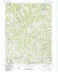
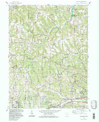
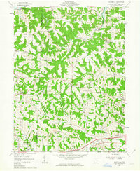 1962 Bloomfield1963 Print · USGSEastern Ohio’s ridgelines and creek valleys are captured here in the early sixties, showing the expansion of New Concord and the local energy economy. Researchers can locate family landmarks like Hawthorne Cem, the Ford Cem, and the historic Lebanon Ch.4 unique versions available
 - 1993 Map of Bloomfield
 1993 Bloomfield1993 Print · USGSGuernsey County's rural landscape is captured here in the early nineties, showing a region defined by winding creek valleys and hilltop settlements. Researchers can trace family history through sites like Indian Camp, Northfield Cem, and the Mt Harmon Ch near the banks of Wills Creek Lake.
 - 1994 Map of Bloomfield, 1998 Print
 1994 Bloomfield1998 Print · USGSGuernsey and Muskingum counties are shown here in the 1990s, captured just before the turn of the century. You can trace family roots at Northfield Cem, locate the Indian Camp Covered Bridge, or find old schools like Pike Sch.
End of results
Showing maps 1-9 of 9
Top cities near Bloomfield
- Coshocton historical maps
- Cambridge historical maps
- Newcomerstown historical maps
- New Concord historical maps
- Byesville historical maps
- West Lafayette historical maps
See more
Frequently asked questions
- What are the different types of historical maps available for Bloomfield?
- What is the oldest map of Bloomfield?
- Where can I purchase historical maps of Bloomfield for my home or office?
- Where can I download high-res historical maps of Bloomfield?
- Are there historical topographic maps available for Bloomfield?
- Is there historical aerial imagery available for Bloomfield?
- Where are historical maps of Bloomfield sourced from?