1960s Maps of New Concord, Ohio
Explore 5 historic maps of New Concord from the 1960s. These maps offer a rare glimpse into what life looked like during the 1960s — showing old roads, neighborhoods, homes, and landmarks that have changed or disappeared over time.
Whether you're researching your family's past, planning a metal detecting trip, or studying how New Concord's landscape evolved across the 1960s, these high-resolution maps are a powerful tool for exploring the history of this region.
- Focus on a specific era: All maps on this page are from the 1960s, giving you a focused view of this time period.
- See what’s changed: Compare century-old streets, trails, and buildings to today's modern landscape using overlays and satellite layers.
- Research with precision: Use these maps for genealogy, historical research, land use analysis, or educational projects.
- View, download, or print: Maps are fully viewable online in high resolution, and can be downloaded or printed for your own records.
Start exploring New Concord's history through authentic maps from the 1960s. This is your window into the past.
New Concord, OH maps
(5)- 1961 Map of Clarksburg
 1961 Clarksburg1961 Print · USGSThe mid-century industrial and river landscapes of West Virginia and Ohio are detailed here, centered on the Ohio River. Researchers can trace the Baltimore and Ohio rail lines connecting towns like Parkersburg, Clarksburg, and Monongah.
 - 1961 Map of Norwich, 1963 Print
 1961 Norwich1963 Print · USGSMuskingum County in the early sixties shows a rural landscape of scattered hamlets and church-centered townships. Genealogists and local historians can trace family locations through Rock Spring Cem, the village of Norwich, and the old Smith Mill site.5 unique versions available
 - 1961 Map of New Concord, 1963 Print
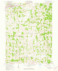 1961 New Concord1963 Print · USGSMuskingum County and the village of New Concord are captured in the early sixties as local industry and campus life expanded. Researchers can trace family roots at Zion Cem or locate former rural landmarks like the Westland Sch and Rix Mills.4 unique versions available
 - 1962 Map of Canton
 1962 Canton1962 Print · USGSThe industrial heartland of Eastern Ohio and Western Pennsylvania thrives in the early sixties as steel mills and rail lines dominate the river valleys. Genealogists and historians can trace local landmarks like McKinley National Memorial, Malone College, and industrial sites such as Republic Steel Corp.2 unique versions available
 - 1962 Map of Bloomfield, 1963 Print
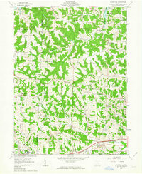 1962 Bloomfield1963 Print · USGSEastern Ohio’s ridgelines and creek valleys are captured here in the early sixties, showing the expansion of New Concord and the local energy economy. Researchers can locate family landmarks like Hawthorne Cem, the Ford Cem, and the historic Lebanon Ch.4 unique versions available
End of results
Showing maps 1-5 of 5
Top cities near New Concord
- Cambridge historical maps
- Byesville historical maps
- Center historical maps
- Franklin historical maps
- Philo historical maps
- Blue Rock historical maps
See more
Top neighborhoods of New Concord
Frequently asked questions
- What are the different types of historical maps available for New Concord?
- What is the oldest map of New Concord?
- Where can I purchase historical maps of New Concord for my home or office?
- Where can I download high-res historical maps of New Concord?
- Are there historical topographic maps available for New Concord?
- Is there historical aerial imagery available for New Concord?
- Where are historical maps of New Concord sourced from?