1900s (20th Century) Maps of Summerfield, Ohio
Explore 9 historic maps of Summerfield from the 1900s (20th Century). These maps offer a rare glimpse into what life looked like during the 1900s — showing old roads, neighborhoods, homes, and landmarks that have changed or disappeared over time.
Whether you're researching your family's past, planning a metal detecting trip, or studying how Summerfield's landscape evolved across the 1900s, these high-resolution maps are a powerful tool for exploring the history of this region.
- Focus on a specific era: All maps on this page are from the 1900s, giving you a focused view of this time period.
- See what’s changed: Compare century-old streets, trails, and buildings to today's modern landscape using overlays and satellite layers.
- Research with precision: Use these maps for genealogy, historical research, land use analysis, or educational projects.
- View, download, or print: Maps are fully viewable online in high resolution, and can be downloaded or printed for your own records.
Start exploring Summerfield's history through authentic maps from the 1900s. This is your window into the past.
Summerfield, OH maps
(9)- 1909 Map of Summerfield, 1958 Print
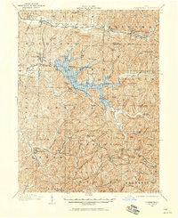 1909 Summerfield1958 Print · USGSSoutheastern Ohio at the turn of the century reveals a landscape of tight-knit rural communities and a dense network of country schools. Researchers can trace the vanished postal routes of Spencers Sta PO, locate St Johns Church, or study the early rail lines through Quaker City.
 - 1911 Map of Summerfield, 1942 Print
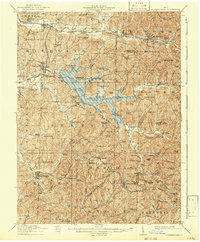 1911 Summerfield1942 Print · USGSSoutheast Ohio’s rural landscape is captured here during a time of peak settlement, showing the region's dense network of family-named ridges and valley farms. Genealogists can trace local roots through numerous landmarks like Richland Church, Kings Mine, and the Science Hill School.
 - 1949 Map of Clarksburg
 1949 Clarksburg1949 Print · USGSThe upper Ohio River valley and the industrial heart of West Virginia come into focus during this post-war period. Genealogists and researchers can trace the rail corridors of the Baltimore and Ohio and locate centers like Fairmont, Grafton, and Waynesburg.
 - 1956 Map of Clarksburg, 1966 Print
 1956 Clarksburg1966 Print · USGSThe Ohio River valley and the industrial heart of West Virginia are seen here in the mid-1950s as rail and river commerce thrived. Researchers can trace historic transport lines like the Baltimore and Ohio RR and locate ancestral homes in Clarksburg, Moundsville, or Parkersburg.2 unique versions available
 - 1961 Map of Clarksburg
 1961 Clarksburg1961 Print · USGSThe mid-century industrial and river landscapes of West Virginia and Ohio are detailed here, centered on the Ohio River. Researchers can trace the Baltimore and Ohio rail lines connecting towns like Parkersburg, Clarksburg, and Monongah.
 - 1961 Map of Summerfield, 1963 Print
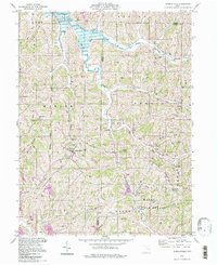
 1961 Summerfield1963 Print · USGSSoutheast Ohio's hill country in the early sixties reveals a landscape of ridge-top farms and emerging energy infrastructure. Researchers can trace family roots at Seneca Valley Church or find legacy settlements like Whigville and Summerfield near the Senecaville Reservoir.2 unique versions available
 - 1980 Map of Senecaville, 1983 Print
 1980 Senecaville1983 Print · USGSEastern Ohio at the start of the eighties reveals a complex landscape of coal extraction and river commerce. Genealogists and historians can trace rail lines like the Conrail and Baltimore and Ohio RR connecting towns like Byesville and Woodsfield.2 unique versions available
 - 1988 Map of Clarksburg, 1989 Print
 1988 Clarksburg1989 Print · USGSThe central Appalachians are documented in detail during the late eighties, showing the industrial and river-based economies of West Virginia, Ohio, and Pennsylvania. Researchers can trace historic rail routes like the B & O RR and locate river towns from St Marys to Parkersburg.
 - 1994 Map of Summerfield, 1998 Print
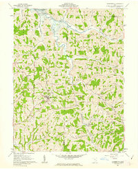
 1994 Summerfield1998 Print · USGSSoutheastern Ohio's ridge country is beautifully detailed here in the mid-1990s, centering on the village of Summerfield and the waters of Senecaville Lake. Genealogists and hikers can locate numerous hillside burial grounds like Calais Cem and Bracken Cem, or trace the winding Little Muskingum River.
End of results
Showing maps 1-9 of 9
Top cities near Summerfield
- Cambridge historical maps
- Barnesville historical maps
- Byesville historical maps
- Woodsfield historical maps
- Caldwell historical maps
- Malaga historical maps
See more
Frequently asked questions
- What are the different types of historical maps available for Summerfield?
- What is the oldest map of Summerfield?
- Where can I purchase historical maps of Summerfield for my home or office?
- Where can I download high-res historical maps of Summerfield?
- Are there historical topographic maps available for Summerfield?
- Is there historical aerial imagery available for Summerfield?
- Where are historical maps of Summerfield sourced from?