1900-1909 Maps of Carroll Township, Ohio
Explore 3 historic maps of Carroll Township from 1900-1909. These maps offer a rare glimpse into what life looked like during the 1900s — showing old roads, neighborhoods, homes, and landmarks that have changed or disappeared over time.
Whether you're researching your family's past, planning a metal detecting trip, or studying how Carroll Township's landscape evolved across the 1900s, these high-resolution maps are a powerful tool for exploring the history of this region.
- Focus on a specific era: All maps on this page are from the 1900s, giving you a focused view of this time period.
- See what’s changed: Compare century-old streets, trails, and buildings to today's modern landscape using overlays and satellite layers.
- Research with precision: Use these maps for genealogy, historical research, land use analysis, or educational projects.
- View, download, or print: Maps are fully viewable online in high resolution, and can be downloaded or printed for your own records.
Start exploring Carroll Township's history through authentic maps from the 1900s. This is your window into the past.
Carroll Township, OH maps
(3)- 1900 Map of Oak Harbor, 1943 Print
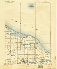 1900 Oak Harbor1943 Print · USGSOttawa County shorelines and rail hubs are preserved here at the turn of the century, showing the region before modern development. Genealogists and historians can trace the early layouts of Oak Harbor, the military grounds at Camp Perry, and the path of the Toledo Div. railroad.2 unique versions available
 - 1901 Map of Put-In-Bay, 1958 Print
 1901 Put-In-Bay1958 Print · USGSOttawa County's shoreline and the famous Lake Erie islands are captured at the start of the twentieth century, before modern development reshaped the coast. Genealogists and historians can trace the rail lines of the Lakeside and Sandusky Line and locate early settlements like Gypsum and St. George.
 - 1903 Map of Put In Bay, 1939 Print
 1903 Put In Bay1939 Print · USGSOttawa County's shoreline and islands are captured in the early twentieth century, showing a world of maritime transit and early rail. Genealogists can trace the early layout of Port Clinton and the distinct settlements of Put in Bay, Gypsum, and Lakeside.
End of results
Showing maps 1-3 of 3
Top cities near Carroll Township
- Port Clinton historical maps
- Oak Harbor historical maps
- Gibsonburg historical maps
- Lindsey historical maps
- Rocky Ridge historical maps
Top neighborhoods of Carroll Township
Frequently asked questions
- What are the different types of historical maps available for Carroll Township?
- What is the oldest map of Carroll Township?
- Where can I purchase historical maps of Carroll Township for my home or office?
- Where can I download high-res historical maps of Carroll Township?
- Are there historical topographic maps available for Carroll Township?
- Is there historical aerial imagery available for Carroll Township?
- Where are historical maps of Carroll Township sourced from?