1960s Maps of Madison Township, Ohio
Explore 6 historic maps of Madison Township from the 1960s. These maps offer a rare glimpse into what life looked like during the 1960s — showing old roads, neighborhoods, homes, and landmarks that have changed or disappeared over time.
Whether you're researching your family's past, planning a metal detecting trip, or studying how Madison Township's landscape evolved across the 1960s, these high-resolution maps are a powerful tool for exploring the history of this region.
- Focus on a specific era: All maps on this page are from the 1960s, giving you a focused view of this time period.
- See what’s changed: Compare century-old streets, trails, and buildings to today's modern landscape using overlays and satellite layers.
- Research with precision: Use these maps for genealogy, historical research, land use analysis, or educational projects.
- View, download, or print: Maps are fully viewable online in high resolution, and can be downloaded or printed for your own records.
Start exploring Madison Township's history through authentic maps from the 1960s. This is your window into the past.
Madison Township, OH maps
(6)- 1960 Map of Pavonia, 1962 Print
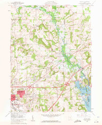 1960 Pavonia1962 Print · USGSRichland and Ashland counties are captured during a period of mid-century suburban growth and water management. Genealogists can trace family names at Smeltzer Cem and Pittenger Cem or locate old landmarks like Pavonia and Windsor.3 unique versions available
 - 1960 Map of Mansfield North, 1962 Print
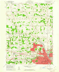 1960 Mansfield North1962 Print · USGSRichland County at the start of the 1960s shows a landscape of heavy industry and vital rail corridors. Trace family history at Sacred Heart Seminary or follow the historic tracks of the Pennsylvania and Baltimore and Ohio railroads.4 unique versions available
 - 1961 Map of Mansfield South, 1962 Print
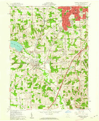 1961 Mansfield South1962 Print · USGSRichland County at the start of the sixties shows a landscape of growing suburbs and rural crossroads. Researchers can trace the expansion of Mansfield south toward Lexington or locate family sites near Hilton Ch and Kings Corners.5 unique versions available
 - 1961 Map of Lucas, 1963 Print
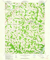 1961 Lucas1963 Print · USGSRichland County at the start of the 1960s reveals a landscape of watershed management and traditional rail-bound commerce. Genealogists and historians can trace family locations through numerous small burying grounds like Mt Olive Cem and historic sites such as Culler Mill near Lucas.3 unique versions available
 - 1962 Map of Marion
 1962 Marion1962 Print · USGSCentral Ohio during the post-war era showcases a dense network of railroad towns and emerging interstate highways. Genealogists can trace family roots in smaller settlements like Houcktown and Marseilles or locate landmarks near Indian Lake.
 - 1966 Map of Marion, 1968 Print
 1966 Marion1968 Print · USGSCentral Ohio in the mid-sixties is captured during a period of rapid highway expansion and industrial connectivity. Genealogists and historians can trace rail-and-river networks through towns like Marion, Urbana, and Mount Vernon, or locate landmarks such as Malabar Farm and Black Hand Rock.3 unique versions available
End of results
Showing maps 1-6 of 6
Top cities near Madison Township
- Mansfield historical maps
- Ashland historical maps
- Galion historical maps
- Shelby historical maps
- Ontario historical maps
- Crestline historical maps
See more
Top neighborhoods of Madison Township
- East Mansfield historical maps
- Lincoln Heights historical maps
- Alta historical maps
- Roseland historical maps
- Wooster Heights historical maps
Frequently asked questions
- What are the different types of historical maps available for Madison Township?
- What is the oldest map of Madison Township?
- Where can I purchase historical maps of Madison Township for my home or office?
- Where can I download high-res historical maps of Madison Township?
- Are there historical topographic maps available for Madison Township?
- Is there historical aerial imagery available for Madison Township?
- Where are historical maps of Madison Township sourced from?