1940s Maps of Monroe Township, Ohio
Explore 1 historic maps of Monroe Township from the 1940s. These maps offer a rare glimpse into what life looked like during the 1940s — showing old roads, neighborhoods, homes, and landmarks that have changed or disappeared over time.
Whether you're researching your family's past, planning a metal detecting trip, or studying how Monroe Township's landscape evolved across the 1940s, these high-resolution maps are a powerful tool for exploring the history of this region.
- Focus on a specific era: All maps on this page are from the 1940s, giving you a focused view of this time period.
- See what’s changed: Compare century-old streets, trails, and buildings to today's modern landscape using overlays and satellite layers.
- Research with precision: Use these maps for genealogy, historical research, land use analysis, or educational projects.
- View, download, or print: Maps are fully viewable online in high resolution, and can be downloaded or printed for your own records.
Start exploring Monroe Township's history through authentic maps from the 1940s. This is your window into the past.
Monroe Township, OH maps
(1)- 1944 Map of Perrysville
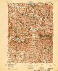 1944 Perrysville1944 Print · USGSThe Mohican River valley in the mid-1940s reveals a transition from traditional milling to modern water management with the Pleasant Hill Reservoir. Genealogists can trace family footprints across dozens of country school sites like Knotty Oak Sch and the vanished crossroads of Black Swamp.
End of results
Showing maps 1-1 of 1
Top cities near Monroe Township
- Mansfield historical maps
- Ashland historical maps
- Ontario historical maps
- Lexington historical maps
- Loudonville historical maps
- Fredericktown historical maps
See more
Top neighborhoods of Monroe Township
- Hastings historical maps
- Pinhook historical maps
- Coulter historical maps
- Culler Mill historical maps
- Richland Cottage Area historical maps
- Lucas historical maps
Frequently asked questions
- What are the different types of historical maps available for Monroe Township?
- What is the oldest map of Monroe Township?
- Where can I purchase historical maps of Monroe Township for my home or office?
- Where can I download high-res historical maps of Monroe Township?
- Are there historical topographic maps available for Monroe Township?
- Is there historical aerial imagery available for Monroe Township?
- Where are historical maps of Monroe Township sourced from?