1950s Maps of Liberty Township, Ohio
Explore 3 historic maps of Liberty Township from the 1950s. These maps offer a rare glimpse into what life looked like during the 1950s — showing old roads, neighborhoods, homes, and landmarks that have changed or disappeared over time.
Whether you're researching your family's past, planning a metal detecting trip, or studying how Liberty Township's landscape evolved across the 1950s, these high-resolution maps are a powerful tool for exploring the history of this region.
- Focus on a specific era: All maps on this page are from the 1950s, giving you a focused view of this time period.
- See what’s changed: Compare century-old streets, trails, and buildings to today's modern landscape using overlays and satellite layers.
- Research with precision: Use these maps for genealogy, historical research, land use analysis, or educational projects.
- View, download, or print: Maps are fully viewable online in high resolution, and can be downloaded or printed for your own records.
Start exploring Liberty Township's history through authentic maps from the 1950s. This is your window into the past.
Liberty Township, OH maps
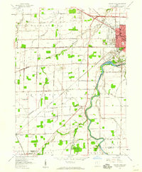
(3)- 1956 Map of Toledo, 1968 Print
 1956 Toledo1968 Print · USGSNorthwest Ohio and the Lake Erie shoreline are shown in detail during the late fifties, showcasing a landscape of heavy industry, railroads, and island communities. Genealogists and historians can trace rail networks like the Chesapeake & Ohio RR or locate landmarks such as the Erie Proving Ground and Kelleys Island.4 unique versions available
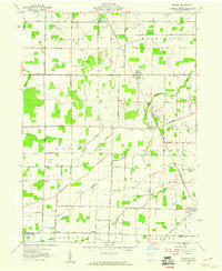
 - 1958 Map of Fremont West, 1960 Print
 1958 Fremont West1960 Print · USGSThe western outskirts of Fremont and the Sandusky River valley are documented here in the late fifties, showcasing a landscape of active oil fields and river crossings. Researchers can trace family history through several rural burial grounds like Hite Cem or locate the Mull Covered Bridge and St Marys Ch.
 - 1959 Map of Helena, 1960 Print
 1959 Helena1960 Print · USGSSandusky County's rural landscape at the close of the 1950s shows a productive mix of agriculture and oil production. Researchers can locate family landmarks like St Marys Cem and Smith Cem, or trace the rail lines through Helena and Burgoon.2 unique versions available
End of results
Showing maps 1-3 of 3
Top cities near Liberty Township
- Tiffin historical maps
- Fremont historical maps
- Fostoria historical maps
- Green Creek historical maps
- Ballville historical maps
- Gibsonburg historical maps
See more
Top neighborhoods of Liberty Township
- Maple Grove historical maps
- Angus historical maps
- Mount Gilead historical maps
- Cromers historical maps
- Kansas historical maps
- Bettsville historical maps
Frequently asked questions
- What are the different types of historical maps available for Liberty Township?
- What is the oldest map of Liberty Township?
- Where can I purchase historical maps of Liberty Township for my home or office?
- Where can I download high-res historical maps of Liberty Township?
- Are there historical topographic maps available for Liberty Township?
- Is there historical aerial imagery available for Liberty Township?
- Where are historical maps of Liberty Township sourced from?