1990s Maps of Cuyahoga Falls, Ohio
Explore 5 historic maps of Cuyahoga Falls from the 1990s. These maps offer a rare glimpse into what life looked like during the 1990s — showing old roads, neighborhoods, homes, and landmarks that have changed or disappeared over time.
Whether you're researching your family's past, planning a metal detecting trip, or studying how Cuyahoga Falls's landscape evolved across the 1990s, these high-resolution maps are a powerful tool for exploring the history of this region.
- Focus on a specific era: All maps on this page are from the 1990s, giving you a focused view of this time period.
- See what’s changed: Compare century-old streets, trails, and buildings to today's modern landscape using overlays and satellite layers.
- Research with precision: Use these maps for genealogy, historical research, land use analysis, or educational projects.
- View, download, or print: Maps are fully viewable online in high resolution, and can be downloaded or printed for your own records.
Start exploring Cuyahoga Falls's history through authentic maps from the 1990s. This is your window into the past.
Cuyahoga Falls, OH maps
(5)- 1994 Map of Cleveland South
 1994 Cleveland South1994 Print · USGSThe metropolitan corridor between Akron and Cleveland is shown here in the mid-nineties during a period of significant suburban growth. Researchers can trace the path of the Ohio Turnpike or explore expansive recreation lands like West Branch State Park.
 - 1994 Map of Akron West, 1997 Print
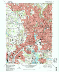 1994 Akron West1997 Print · USGSGreater Akron and Barberton are shown in the mid-1990s as the urban landscape continues to evolve around its historic water and rail corridors. Trace your local history through landmarks like Summit Lake, the Rubber Bowl, and Holy Cross Cem.
 - 1994 Map of Akron East, 1997 Print
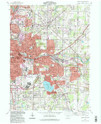 1994 Akron East1997 Print · USGSEastern Akron and its neighbors in the mid-1990s show a region shaped by industry and aviation. Researchers can trace local history at the Goodyear Airdock, Tallmadge Cemetery, and the shores of Springfield Lake.
 - 1994 Map of Peninsula, 1997 Print
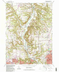 1994 Peninsula1997 Print · USGSIn the mid-nineties, the Cuyahoga Valley remained a preserved corridor of natural terrain between the growing industrial hubs of Akron and Cleveland. Researchers can trace historic cemeteries like Ira Cem, the route of the Ohio Canal, and landmarks like Ritchie Ledges.
 - 1994 Map of Hudson, 2000 Print
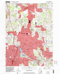 1994 Hudson2000 Print · USGSNortheast Ohio's suburban landscape comes into focus during the 1990s as the cities of Hudson and Stow expand toward the Cuyahoga Valley. Genealogists and local historians can trace legacy sites like Western Reserve Academy and Markillie Cem amidst the era's growing neighborhoods.
End of results
Showing maps 1-5 of 5
Top cities near Cuyahoga Falls
- Akron historical maps
- Parma historical maps
- Stow historical maps
- North Royalton historical maps
- Garfield Heights historical maps
- Kent historical maps
See more
Top neighborhoods of Cuyahoga Falls
- West Steels Corners historical maps
- Northampton Center historical maps
- East Steels Corners historical maps
- Brook Point historical maps
- Chestnut Crossing historical maps
- Underwood historical maps
See more
Frequently asked questions
- What are the different types of historical maps available for Cuyahoga Falls?
- What is the oldest map of Cuyahoga Falls?
- Where can I purchase historical maps of Cuyahoga Falls for my home or office?
- Where can I download high-res historical maps of Cuyahoga Falls?
- Are there historical topographic maps available for Cuyahoga Falls?
- Is there historical aerial imagery available for Cuyahoga Falls?
- Where are historical maps of Cuyahoga Falls sourced from?