1990s Maps of Mizers, Newcomerstown
Explore 2 historic maps of Mizers from the 1990s. These maps offer a rare glimpse into what life looked like during the 1990s — showing old roads, neighborhoods, homes, and landmarks that have changed or disappeared over time.
Whether you're researching your family's past, planning a metal detecting trip, or studying how Mizers's landscape evolved across the 1990s, these high-resolution maps are a powerful tool for exploring the history of this region.
- Focus on a specific era: All maps on this page are from the 1990s, giving you a focused view of this time period.
- See what’s changed: Compare century-old streets, trails, and buildings to today's modern landscape using overlays and satellite layers.
- Research with precision: Use these maps for genealogy, historical research, land use analysis, or educational projects.
- View, download, or print: Maps are fully viewable online in high resolution, and can be downloaded or printed for your own records.
Start exploring Mizers's history through authentic maps from the 1990s. This is your window into the past.
Mizers, Newcomerstown maps
(2)- 1993 Map of Newcomerstown
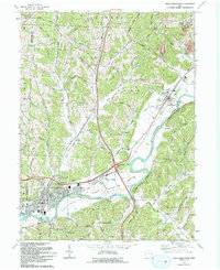 1993 Newcomerstown1993 Print · USGSThe Tuscarawas River valley in the early nineties shows a landscape deeply tied to its industrial and athletic heritage. Genealogists can trace family footprints across Stark Patent lands and find local landmarks like Cy Young Memorial Park and the Centenary Cem.
 - 1994 Map of Newcomerstown, 1998 Print
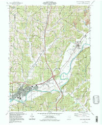 1994 Newcomerstown1998 Print · USGSTuscarawas County in the 1990s shows a landscape where historic river-bottom settlements meet modern transit corridors. Genealogists and historians can trace family landmarks like Mt Zion Cem, the STARK PATENT boundaries, and the Cy Young Memorial Park.
End of results
Showing maps 1-2 of 2
Top cities near Mizers
- New Philadelphia historical maps
- Dover historical maps
- Cambridge historical maps
- Uhrichsville historical maps
- Goshen historical maps
- Newcomerstown historical maps
See more
Frequently asked questions
- What are the different types of historical maps available for Mizers?
- What is the oldest map of Mizers?
- Where can I purchase historical maps of Mizers for my home or office?
- Where can I download high-res historical maps of Mizers?
- Are there historical topographic maps available for Mizers?
- Is there historical aerial imagery available for Mizers?
- Where are historical maps of Mizers sourced from?