1960s Maps of Wooster, Ohio
Explore 3 historic maps of Wooster from the 1960s. These maps offer a rare glimpse into what life looked like during the 1960s — showing old roads, neighborhoods, homes, and landmarks that have changed or disappeared over time.
Whether you're researching your family's past, planning a metal detecting trip, or studying how Wooster's landscape evolved across the 1960s, these high-resolution maps are a powerful tool for exploring the history of this region.
- Focus on a specific era: All maps on this page are from the 1960s, giving you a focused view of this time period.
- See what’s changed: Compare century-old streets, trails, and buildings to today's modern landscape using overlays and satellite layers.
- Research with precision: Use these maps for genealogy, historical research, land use analysis, or educational projects.
- View, download, or print: Maps are fully viewable online in high resolution, and can be downloaded or printed for your own records.
Start exploring Wooster's history through authentic maps from the 1960s. This is your window into the past.
Wooster, OH maps
(3)- 1961 Map of Wooster, 1962 Print
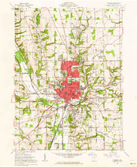 1961 Wooster1962 Print · USGSThe city of Wooster thrives in the early sixties as a regional hub of education and agriculture. Genealogists and historians can trace family-named sites like Burnetts Corners, old cemeteries such as Salem Cem, and the expansive College of Wooster campus.4 unique versions available
 - 1961 Map of Holmesville, 1963 Print
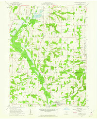 1961 Holmesville1963 Print · USGSThe agricultural and industrial character of the Wayne and Holmes County border is revealed in the early 1960s. Genealogists and historians can trace the Pennsylvania Railroad Grade through Holmesville or locate rural sites like Moorhead Ch and Franklin Sch.4 unique versions available
 - 1962 Map of Canton
 1962 Canton1962 Print · USGSThe industrial heartland of Eastern Ohio and Western Pennsylvania thrives in the early sixties as steel mills and rail lines dominate the river valleys. Genealogists and historians can trace local landmarks like McKinley National Memorial, Malone College, and industrial sites such as Republic Steel Corp.2 unique versions available
End of results
Showing maps 1-3 of 3
Top cities near Wooster
- Wadsworth historical maps
- Orrville historical maps
- East Union historical maps
- Rittman historical maps
- Lodi historical maps
- Doylestown historical maps
See more
Top neighborhoods of Wooster
- Boys Village historical maps
- Madison Hill historical maps
- Madisonburg historical maps
- Miller Lake historical maps
- Wooster Public Square Historic District historical maps
Frequently asked questions
- What are the different types of historical maps available for Wooster?
- What is the oldest map of Wooster?
- Where can I purchase historical maps of Wooster for my home or office?
- Where can I download high-res historical maps of Wooster?
- Are there historical topographic maps available for Wooster?
- Is there historical aerial imagery available for Wooster?
- Where are historical maps of Wooster sourced from?