1900s (20th Century) Maps of Duland, Oklahoma
Explore 8 historic maps of Duland from the 1900s (20th Century). These maps offer a rare glimpse into what life looked like during the 1900s — showing old roads, neighborhoods, homes, and landmarks that have changed or disappeared over time.
Whether you're researching your family's past, planning a metal detecting trip, or studying how Duland's landscape evolved across the 1900s, these high-resolution maps are a powerful tool for exploring the history of this region.
- Focus on a specific era: All maps on this page are from the 1900s, giving you a focused view of this time period.
- See what’s changed: Compare century-old streets, trails, and buildings to today's modern landscape using overlays and satellite layers.
- Research with precision: Use these maps for genealogy, historical research, land use analysis, or educational projects.
- View, download, or print: Maps are fully viewable online in high resolution, and can be downloaded or printed for your own records.
Start exploring Duland's history through authentic maps from the 1900s. This is your window into the past.
Duland, OK maps
(8)- 1903 Map of Paris
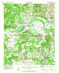
 1903 Paris1903 Print · USGSThe Red River borderlands of the Indian Territory and Texas are shown here at the start of the century. Genealogists and researchers can trace early settlements and social hubs like Grant, Oberlin, and the Camp Ground along the winding banks of the Red River.
 - 1948 Map of Grant, 1963 Print
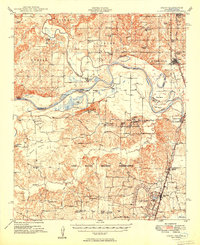
 1948 Grant1963 Print · USGSThe Red River borderlands of Oklahoma and Texas are shown here in the late 1940s, featuring the extensive Camp Maxey Military Reservation. Researchers can trace the St Louis San Francisco Railway through Grant and locate dozens of local landmarks like Hills Chapel School and Goodland Cem.2 unique versions available
 - 1949 Map of Grant
 1949 Grant1949 Print · USGSThe Red River borderlands of Oklahoma and Texas are captured here just after the war, showing a rural landscape dominated by large river bends and military expansion. You can trace early community hubs like Grant and Arthur City or locate local landmarks like Hills Chapel School and Forest Chapel.2 unique versions available
 - 1953 Map of Texarkana, 1964 Print
 1953 Texarkana1964 Print · USGSThe Texas-Arkansas borderlands are captured here in the mid-fifties, during a decade of massive military and hydraulic engineering projects. Genealogists and researchers can locate family landmarks like Old Boston Cem, Siloam Ch, and the vast Red River Arsenal.4 unique versions available
 - 1956 Map of Texarkana
 1956 Texarkana1956 Print · USGSThe Ark-La-Tex borderlands come alive in the mid-fifties, showing the transition from a rail-dependent rural economy to a post-war industrial landscape. Researchers can trace the massive Red River Ordnance Depot and find towns like Talco, Bogata, and Naples.
 - 1980 Map of Bluff, 1981 Print
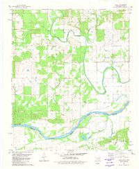 1980 Bluff1981 Print · USGSThe Oklahoma-Texas border comes into focus in the early eighties as the Red River separates Choctaw and Lamar counties. Researchers can trace rural life through landmarks like St Paul Ch, Bluff Cem, and the small settlement of Gay.2 unique versions available
 - 1985 Map of Paris
 1985 Paris1985 Print · USGSThe Red River Valley in the mid-eighties shows a landscape of military training grounds and rail-connected agricultural towns. Genealogists and historians can trace local landmarks like Allens Chapel Cem, the grounds of Camp Maxey, and the early footprint of Paris Junior College.
 - 1991 Map of Paris
 1991 Paris1991 Print · USGSNorthern Texas and southern Oklahoma meet along the Red River valley during the early nineties. Researchers can trace the rail networks of the Texas and Pacific RR and visit rural communities like Manchester, Sylvan, and Arthur City.
End of results
Showing maps 1-8 of 8
Top cities near Duland
Frequently asked questions
- What are the different types of historical maps available for Duland?
- What is the oldest map of Duland?
- Where can I purchase historical maps of Duland for my home or office?
- Where can I download high-res historical maps of Duland?
- Are there historical topographic maps available for Duland?
- Is there historical aerial imagery available for Duland?
- Where are historical maps of Duland sourced from?