1950s Maps of Asian District, Oklahoma City
Explore 5 historic maps of Asian District from the 1950s. These maps offer a rare glimpse into what life looked like during the 1950s — showing old roads, neighborhoods, homes, and landmarks that have changed or disappeared over time.
Whether you're researching your family's past, planning a metal detecting trip, or studying how Asian District's landscape evolved across the 1950s, these high-resolution maps are a powerful tool for exploring the history of this region.
- Focus on a specific era: All maps on this page are from the 1950s, giving you a focused view of this time period.
- See what’s changed: Compare century-old streets, trails, and buildings to today's modern landscape using overlays and satellite layers.
- Research with precision: Use these maps for genealogy, historical research, land use analysis, or educational projects.
- View, download, or print: Maps are fully viewable online in high resolution, and can be downloaded or printed for your own records.
Start exploring Asian District's history through authentic maps from the 1950s. This is your window into the past.
Asian District, Oklahoma City maps
(5)- 1951 Map of Britton, 1952 Print
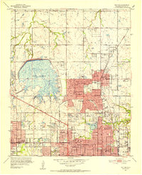 1951 Britton1952 Print · USGSOklahoma City's northern suburbs were rapidly evolving in the early fifties as residential tracts began to surround the massive Lake Hefner. Genealogists and historians can trace the growth of Britton, Nichols Hills, and Warr Acres alongside landmarks like Rose Hill Burial Park and the Wiley Post Airport.6 unique versions available
 - 1954 Map of Oklahoma City
 1954 Oklahoma City1954 Print · USGSOklahoma City and its surrounding counties are captured here in the early fifties during a period of significant postwar growth. Researchers can trace the development of the Turner Turnpike and locate aviation hubs like Tinker Field or Will Rogers Field.
 - 1956 Map of Oklahoma City, 1957 Print
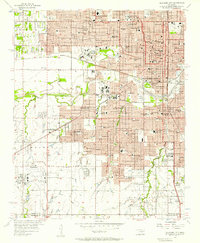 1956 Oklahoma City1957 Print · USGSOklahoma City emerges as a bustling mid-century hub at the intersection of major rail lines and early aviation history. Genealogists and historians can trace the development of urban neighborhoods and local institutions from Fairlawn Cemetery to the Will Rogers Municipal Airport.3 unique versions available
 - 1956 Map of Oklahoma City, 1957 Print
 1956 Oklahoma City1957 Print · USGSCentral Oklahoma in the mid-fifties shows the transition from a rail-centered capital to a modern aviation and oil hub. Researchers can trace family roots through neighborhood landmarks like St Patricks Sch, Fairlawn Cem, and the old Union Station.2 unique versions available
 - 1957 Map of Oklahoma City, 1969 Print
 1957 Oklahoma City1969 Print · USGSCentral Oklahoma is captured here in a period of significant mid-century growth and industrialization. Researchers can trace family roots through numerous rural markers like Memory Lane Cem, New Hope School, and the sprawling grounds of Tinker Air Force Base.3 unique versions available
End of results
Showing maps 1-5 of 5
Frequently asked questions
- What are the different types of historical maps available for Asian District?
- What is the oldest map of Asian District?
- Where can I purchase historical maps of Asian District for my home or office?
- Where can I download high-res historical maps of Asian District?
- Are there historical topographic maps available for Asian District?
- Is there historical aerial imagery available for Asian District?
- Where are historical maps of Asian District sourced from?