1980s Maps of Hares Lincoln Boulevard, Oklahoma City
Explore 2 historic maps of Hares Lincoln Boulevard from the 1980s. These maps offer a rare glimpse into what life looked like during the 1980s — showing old roads, neighborhoods, homes, and landmarks that have changed or disappeared over time.
Whether you're researching your family's past, planning a metal detecting trip, or studying how Hares Lincoln Boulevard's landscape evolved across the 1980s, these high-resolution maps are a powerful tool for exploring the history of this region.
- Focus on a specific era: All maps on this page are from the 1980s, giving you a focused view of this time period.
- See what’s changed: Compare century-old streets, trails, and buildings to today's modern landscape using overlays and satellite layers.
- Research with precision: Use these maps for genealogy, historical research, land use analysis, or educational projects.
- View, download, or print: Maps are fully viewable online in high resolution, and can be downloaded or printed for your own records.
Start exploring Hares Lincoln Boulevard's history through authentic maps from the 1980s. This is your window into the past.
Hares Lincoln Boulevard, Oklahoma City maps
(2)- 1986 Map of Spencer
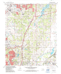 1986 Spencer1986 Print · USGSOklahoma City and Edmond undergo significant expansion during the mid-eighties as new reservoirs and highways reshape the suburban landscape. Genealogists and historians can trace numerous sites like Memorial Park Cemetery, Lake Aluma, and the Cowboy Hall of Fame.
 - 1986 Map of Britton, 1987 Print
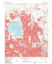 1986 Britton1987 Print · USGSOklahoma City's northern suburbs reached a period of rapid residential and commercial expansion during the mid-eighties. Researchers can trace the layout of Nichols Hills and The Village, locating landmarks like Rose Hill Burial Park and the historic rails of Britton.
End of results
Showing maps 1-2 of 2
Frequently asked questions
- What are the different types of historical maps available for Hares Lincoln Boulevard?
- What is the oldest map of Hares Lincoln Boulevard?
- Where can I purchase historical maps of Hares Lincoln Boulevard for my home or office?
- Where can I download high-res historical maps of Hares Lincoln Boulevard?
- Are there historical topographic maps available for Hares Lincoln Boulevard?
- Is there historical aerial imagery available for Hares Lincoln Boulevard?
- Where are historical maps of Hares Lincoln Boulevard sourced from?