1900s (20th Century) Maps of Orlando, Oklahoma
Explore 6 historic maps of Orlando from the 1900s (20th Century). These maps offer a rare glimpse into what life looked like during the 1900s — showing old roads, neighborhoods, homes, and landmarks that have changed or disappeared over time.
Whether you're researching your family's past, planning a metal detecting trip, or studying how Orlando's landscape evolved across the 1900s, these high-resolution maps are a powerful tool for exploring the history of this region.
- Focus on a specific era: All maps on this page are from the 1900s, giving you a focused view of this time period.
- See what’s changed: Compare century-old streets, trails, and buildings to today's modern landscape using overlays and satellite layers.
- Research with precision: Use these maps for genealogy, historical research, land use analysis, or educational projects.
- View, download, or print: Maps are fully viewable online in high resolution, and can be downloaded or printed for your own records.
Start exploring Orlando's history through authentic maps from the 1900s. This is your window into the past.
Orlando, OK maps
(6)- 1955 Map of Enid, 1966 Print
 1955 Enid1966 Print · USGSNorth-central Oklahoma's transition from open plains to the blackjack hills of the Osage Indian Reservation is captured in the mid-1950s. Researchers can trace the development of the Naval Reserve Oil Field, the grounds of Vance AFB, and the early footprints of Tulsa and Stillwater.4 unique versions available
 - 1958 Map of Enid
 1958 Enid1958 Print · USGSNorthern Oklahoma is mapped here in the late fifties, showcasing a dense network of petroleum production and historic tribal lands. Researchers can trace the legacy of the Osage Indian Reservation, early energy hubs like the Cushing Oil Field, and the Chilocco Indian Agricultural School.2 unique versions available
 - 1974 Map of Orlando East, 1977 Print
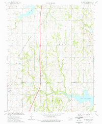 1974 Orlando East1977 Print · USGSNear the intersection of Noble, Logan, and Payne counties in the mid-1970s, this area reflects a landscape shaped by oil production and rail transport. Genealogists and historians can trace Orlando and Fairview Cem alongside the Atchison Topeka and Santa Fe tracks.
 - 1974 Map of Clear Creek, 1977 Print
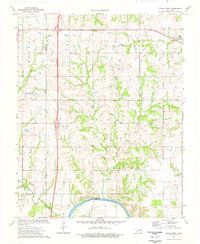 1974 Clear Creek1977 Print · USGSThe rural border of Logan and Payne counties comes alive in the mid-seventies as an active extraction zone. Trace family history at Morris Heights Cem or follow the waters of the Cimarron River and Clear Creek.
 - 1974 Map of Orlando West, 1977 Print
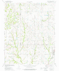 1974 Orlando West1977 Print · USGSThe Noble and Logan county line in the mid-1970s shows a landscape of petroleum extraction and rural crossroads. Researchers can trace local genealogy and industry through the Atchison Topeka and Santa Fe rail line, German Cem, and Orlando.
 - 1990 Map of Enid
 1990 Enid1990 Print · USGSNorth-central Oklahoma's aviation and energy hubs are captured in the 1990s, from the streets of Stillwater to the runways of Vance Air Force Base. Researchers can locate active Oil and Gas Fields and trace local waterways like Skeleton Creek and Black Bear Creek.
End of results
Showing maps 1-6 of 6
Top cities near Orlando
- Stillwater historical maps
- Perry historical maps
- Langston historical maps
- Crescent historical maps
- Covington historical maps
- Coyle historical maps
Frequently asked questions
- What are the different types of historical maps available for Orlando?
- What is the oldest map of Orlando?
- Where can I purchase historical maps of Orlando for my home or office?
- Where can I download high-res historical maps of Orlando?
- Are there historical topographic maps available for Orlando?
- Is there historical aerial imagery available for Orlando?
- Where are historical maps of Orlando sourced from?