1900s (20th Century) Maps of Rankin, Oklahoma
Explore 7 historic maps of Rankin from the 1900s (20th Century). These maps offer a rare glimpse into what life looked like during the 1900s — showing old roads, neighborhoods, homes, and landmarks that have changed or disappeared over time.
Whether you're researching your family's past, planning a metal detecting trip, or studying how Rankin's landscape evolved across the 1900s, these high-resolution maps are a powerful tool for exploring the history of this region.
- Focus on a specific era: All maps on this page are from the 1900s, giving you a focused view of this time period.
- See what’s changed: Compare century-old streets, trails, and buildings to today's modern landscape using overlays and satellite layers.
- Research with precision: Use these maps for genealogy, historical research, land use analysis, or educational projects.
- View, download, or print: Maps are fully viewable online in high resolution, and can be downloaded or printed for your own records.
Start exploring Rankin's history through authentic maps from the 1900s. This is your window into the past.
Rankin, OK maps
(7)- 1955 Map of Clinton, 1964 Print
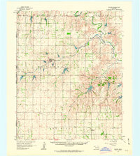
 1955 Clinton1964 Print · USGSWestern Oklahoma during the mid-century transition shows a landscape of growing reservoirs and active military flight lines. Genealogists and historians can locate rural landmarks such as Mountain View Church, Berlin School, and the Riverside Indian School Reserve.3 unique versions available
 - 1957 Map of Clinton
 1957 Clinton1957 Print · USGSWestern Oklahoma in the mid-fifties is captured here as a landscape of river-valley settlements and emerging energy fields. Genealogists can trace family roots through numerous rural landmarks like the Swapping Back Indian School, Hebron Church, and the Riverside Indian School Reserve.
 - 1961 Map of Reydon, 1963 Print
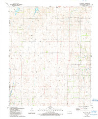
 1961 Reydon1963 Print · USGSWestern Oklahoma’s ranching and rail landscape comes into focus during the early sixties, showing the transition from frontier settlements to modern agricultural hubs. Genealogists and historians can locate family sites like Union Chapel Cem and follow the route of the Panhandle and Santa Fe railroad through Reydon.3 unique versions available
 - 1984 Map of Foss Reservoir
 1984 Foss Reservoir1984 Print · USGSWestern Oklahoma’s river valleys and prairie grasslands are captured here in the mid-eighties, a period of established reservoirs and active energy production. Researchers can trace rural lineages through local hubs like Cheyenne and Hammon or locate landmarks such as the Antelope Hills and Foss Reservoir.
 - 1989 Map of Reydon SW
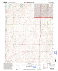
 1989 Reydon SW1989 Print · USGSThe Oklahoma-Texas borderlands come into focus in the late eighties, showing a landscape defined by public grasslands and energy extraction. Genealogists and historians can locate Rankin, the White Rose Cem, and the Petersen Landing Strip among a network of rural drill holes.
 - 1990 Map of Foss Reservoir, 1991 Print
 1990 Foss Reservoir1991 Print · USGSWestern Oklahoma’s prairie and river systems are shown here as they appeared in the 1990s, dominated by conservation lands and water management. Researchers can trace the rail paths of the Atchison Topeka and Santa Fe and locate old rural centers like Strong City and Hammon.
 - 1998 Map of Reydon SW, 2001 Print
 1998 Reydon SW2001 Print · USGSWestern Oklahoma in the late nineties shows a landscape defined by ranching, energy extraction, and conservation. Genealogists and researchers can trace the White Rose Cem, the Petersen Landing Strip, and the bounds of the Black Kettle National Grassland.
End of results
Showing maps 1-7 of 7
Top cities near Rankin
Frequently asked questions
- What are the different types of historical maps available for Rankin?
- What is the oldest map of Rankin?
- Where can I purchase historical maps of Rankin for my home or office?
- Where can I download high-res historical maps of Rankin?
- Are there historical topographic maps available for Rankin?
- Is there historical aerial imagery available for Rankin?
- Where are historical maps of Rankin sourced from?