1970s Maps of Draperville, Albany
Explore 2 historic maps of Draperville from the 1970s. These maps offer a rare glimpse into what life looked like during the 1970s — showing old roads, neighborhoods, homes, and landmarks that have changed or disappeared over time.
Whether you're researching your family's past, planning a metal detecting trip, or studying how Draperville's landscape evolved across the 1970s, these high-resolution maps are a powerful tool for exploring the history of this region.
- Focus on a specific era: All maps on this page are from the 1970s, giving you a focused view of this time period.
- See what’s changed: Compare century-old streets, trails, and buildings to today's modern landscape using overlays and satellite layers.
- Research with precision: Use these maps for genealogy, historical research, land use analysis, or educational projects.
- View, download, or print: Maps are fully viewable online in high resolution, and can be downloaded or printed for your own records.
Start exploring Draperville's history through authentic maps from the 1970s. This is your window into the past.
Draperville, Albany maps
(2)- 1970 Map of Albany, 1972 Print
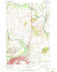 1970 Albany1972 Print · USGSThe Albany and Jefferson corridor in the early seventies shows a landscape defined by the WILLAMETTE RIVER and major rail lines. Genealogists can trace family roots through numerous sites like Waverly Cemetery, Dever School, and Hale Butte.3 unique versions available
 - 1976 Map of Albany, 1980 Print
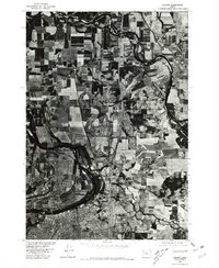 1976 Albany1980 Print · USGSThe Willamette Valley at the Bicentennial is captured in this orthophotograph, showcasing the agricultural heart of Oregon. Researchers can trace the mid-century footprints of Albany, North Albany, and Jefferson along the winding Santiam River.
End of results
Showing maps 1-2 of 2
Frequently asked questions
- What are the different types of historical maps available for Draperville?
- What is the oldest map of Draperville?
- Where can I purchase historical maps of Draperville for my home or office?
- Where can I download high-res historical maps of Draperville?
- Are there historical topographic maps available for Draperville?
- Is there historical aerial imagery available for Draperville?
- Where are historical maps of Draperville sourced from?