1900s (20th Century) Maps of Halfway, Oregon
Explore 7 historic maps of Halfway from the 1900s (20th Century). These maps offer a rare glimpse into what life looked like during the 1900s — showing old roads, neighborhoods, homes, and landmarks that have changed or disappeared over time.
Whether you're researching your family's past, planning a metal detecting trip, or studying how Halfway's landscape evolved across the 1900s, these high-resolution maps are a powerful tool for exploring the history of this region.
- Focus on a specific era: All maps on this page are from the 1900s, giving you a focused view of this time period.
- See what’s changed: Compare century-old streets, trails, and buildings to today's modern landscape using overlays and satellite layers.
- Research with precision: Use these maps for genealogy, historical research, land use analysis, or educational projects.
- View, download, or print: Maps are fully viewable online in high resolution, and can be downloaded or printed for your own records.
Start exploring Halfway's history through authentic maps from the 1900s. This is your window into the past.
Halfway, OR maps
(7)- 1915 Map of Pine
 1915 Pine1915 Print · USGSEastern Oregon was a hub of gold mining and river commerce in the early twentieth century. Researchers can trace the legacy of pioneer families and industry at the Sanger Mine, follow the old Oregon-Washington Railroad, or locate the Mineral P O along the river.3 unique versions available
 - 1955 Map of Baker, 1964 Print
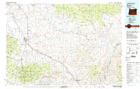
 1955 Baker1964 Print · USGSThe Oregon-Idaho borderlands are captured here in the mid-fifties as the Snake River underwent massive changes from dam construction. Trace the Oregon Trail Memorial Monument near Baker, find early mines like Virtue Mine, and follow the Union Pacific Railroad through Huntington.4 unique versions available
 - 1957 Map of Halfway, 1958 Print
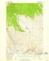 1957 Halfway1958 Print · USGSEagle Valley and the surrounding Whitman National Forest are shown in the late fifties, just before the landscape was altered by hydroelectric development. Researchers can trace the original site of Robinette before it was submerged, alongside local landmarks like Union HS and Mehlhorn Mill.2 unique versions available
 - 1959 Map of Baker
 1959 Baker1959 Print · USGSThe Oregon and Idaho borderlands come alive in the late fifties, showing the rugged corridor along the Snake River and the high peaks of the Wallowa Mountains. Researchers can trace the legacy of the Union Pacific railroad or locate historic mining sites like the Flagstaff Mine and Virtue Mine.2 unique versions available
 - 1981 Map of Baker
 1981 Baker1981 Print · USGSEastern Oregon in the early eighties shows a landscape of deep canyons and high mountain mining districts. Genealogists and researchers can trace the Union Pacific corridor through Baker or locate remote operations like the Young American Mine and Rachel Mine.2 unique versions available
 - 1987 Map of Halfway
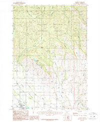 1987 Halfway1987 Print · USGSThe town of Halfway and the surrounding Pine Valley are captured here in the late eighties as they transition from the high Wallowa wilderness to productive valley lands. Researchers can trace the layout of Halfway and Sunset, or locate landmarks like Mehlhorn Butte and Bearwallow Reservoir.
 - 1987 Map of Posy Valley
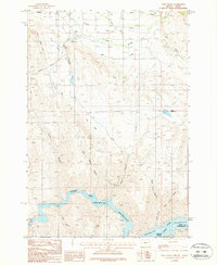 1987 Posy Valley1987 Print · USGSEastern Oregon ranching and river life are captured here in the late eighties, showing the confluence of the Powder River and Brownlee Reservoir. Genealogists can trace the rural layout of Halfway and Pine, alongside local landmarks like the Fairground and Pine Ranger Station.
End of results
Showing maps 1-7 of 7
Top cities near Halfway
Frequently asked questions
- What are the different types of historical maps available for Halfway?
- What is the oldest map of Halfway?
- Where can I purchase historical maps of Halfway for my home or office?
- Where can I download high-res historical maps of Halfway?
- Are there historical topographic maps available for Halfway?
- Is there historical aerial imagery available for Halfway?
- Where are historical maps of Halfway sourced from?