1960s Maps of Currinsville, Oregon
Explore 4 historic maps of Currinsville from the 1960s. These maps offer a rare glimpse into what life looked like during the 1960s — showing old roads, neighborhoods, homes, and landmarks that have changed or disappeared over time.
Whether you're researching your family's past, planning a metal detecting trip, or studying how Currinsville's landscape evolved across the 1960s, these high-resolution maps are a powerful tool for exploring the history of this region.
- Focus on a specific era: All maps on this page are from the 1960s, giving you a focused view of this time period.
- See what’s changed: Compare century-old streets, trails, and buildings to today's modern landscape using overlays and satellite layers.
- Research with precision: Use these maps for genealogy, historical research, land use analysis, or educational projects.
- View, download, or print: Maps are fully viewable online in high resolution, and can be downloaded or printed for your own records.
Start exploring Currinsville's history through authentic maps from the 1960s. This is your window into the past.
Currinsville, OR maps
(4)- 1960 Map of Estacada
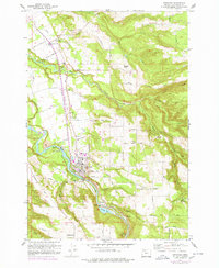 1960 Estacada1960 Print · USGSClackamas County communities and river-based industry thrive in the early 1960s along the Clackamas River. Genealogists and researchers can trace the Abandoned Railroad through Eagle Creek or locate the River Mill Powerhouse and Forrester Cem.
 - 1961 Map of Estacada
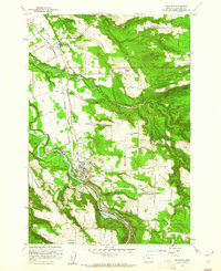 1961 Estacada1961 Print · USGSClackamas County hydroelectric power and timber transport define this early 1960s study of the Estacada area. Researchers can trace the Portland Traction Co rail line or locate family sites like Forrester Cem and the settlement of Currinsville.4 unique versions available
 - 1961 Map of Sandy, 1962 Print
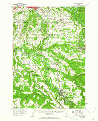 1961 Sandy1962 Print · USGSClackamas County was a landscape of river-driven industry and rural crossroads in the early sixties. Researchers can trace historic river crossings at the Feldheimer Ferry (Site), find the Fischers Mill site, and locate early schools like Damascus Union Sch.
 - 1964 Map of Vancouver
 1964 Vancouver1964 Print · USGSThe Pacific Northwest interior and coast are shown here in the 1960s, from the Portland metropolitan hub to the rugged Pacific shoreline. Researchers can trace the legacy of the Grand Ronde Indian Reservation, the early layout of McMinnville, and the maritime approaches near Tillamook Head.
End of results
Showing maps 1-4 of 4
Top cities near Currinsville
- Portland historical maps
- Gresham historical maps
- Oregon City historical maps
- Happy Valley historical maps
- Springdale historical maps
- Troutdale historical maps
See more
Frequently asked questions
- What are the different types of historical maps available for Currinsville?
- What is the oldest map of Currinsville?
- Where can I purchase historical maps of Currinsville for my home or office?
- Where can I download high-res historical maps of Currinsville?
- Are there historical topographic maps available for Currinsville?
- Is there historical aerial imagery available for Currinsville?
- Where are historical maps of Currinsville sourced from?