1900s (20th Century) Maps of Government Camp, Oregon
Explore 9 historic maps of Government Camp from the 1900s (20th Century). These maps offer a rare glimpse into what life looked like during the 1900s — showing old roads, neighborhoods, homes, and landmarks that have changed or disappeared over time.
Whether you're researching your family's past, planning a metal detecting trip, or studying how Government Camp's landscape evolved across the 1900s, these high-resolution maps are a powerful tool for exploring the history of this region.
- Focus on a specific era: All maps on this page are from the 1900s, giving you a focused view of this time period.
- See what’s changed: Compare century-old streets, trails, and buildings to today's modern landscape using overlays and satellite layers.
- Research with precision: Use these maps for genealogy, historical research, land use analysis, or educational projects.
- View, download, or print: Maps are fully viewable online in high resolution, and can be downloaded or printed for your own records.
Start exploring Government Camp's history through authentic maps from the 1900s. This is your window into the past.
Government Camp, OR maps
(9)- 1924 Map of Mount Hood, 1955 Print
 1924 Mount Hood1955 Print · USGSMount Hood and its surrounding high-country settlements are captured here in the mid-twenties during the rise of mountain recreation. Trace early roads and landmarks like the Mt Hood Loop Highway, Government Camp, and the original Timberline Cabin.2 unique versions available
 - 1927 Map of Mount Hood
 1927 Mount Hood1927 Print · USGSThe northern Cascades transition from pioneer travel routes to early forest management in the mid-1920s. Researchers can trace the legendary Barlow Road, locate historic mountain retreats like the Cloud Cap Inn, and find early outposts at Government Camp.4 unique versions available
 - 1953 Map of The Dalles, 1965 Print
 1953 The Dalles1965 Print · USGSThe Columbia River Gorge at mid-century shows a region being transformed by massive hydroelectric dams and a growing highway network. Researchers can trace the development of The Dalles Dam, locate the Maryhill Museum, and find old rail stops in Rufus, Wishram, and Arlington.3 unique versions available
 - 1956 Map of The Dalles
 1956 The Dalles1956 Print · USGSThe Columbia River Gorge and the high Cascades are captured in the mid-1950s, showing a vital corridor of rail and road. Researchers can trace the original path of The Old Oregon Trail or locate historical landmarks like the Maryhill Museum and Mount Hood.
 - 1957 Map of The Dalles
 1957 The Dalles1957 Print · USGSThe Columbia River Gorge and the high plateaus of the mid-1950s come alive on this detailed survey of northern Oregon and southern Washington. Researchers can trace the path of the Oregon Trail and The Old Barlow Road alongside river towns like The Dalles and Wishram.
 - 1962 Map of Government Camp, 1964 Print
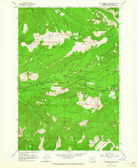 1962 Government Camp1964 Print · USGSGovernment Camp and the high ridges of the Cascades are captured in the early sixties as the region solidified its role in mountaineering and recreation. Trace the historic paths of the Skyline Trail and Pioneer Bridle Trail or locate early forest fire lookouts at Zigzag East Lookout and Devils Peak Lookout.4 unique versions available
 - 1980 Map of Government Camp
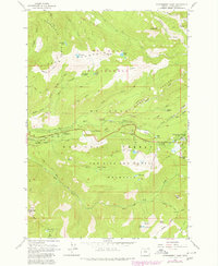 1980 Government Camp1980 Print · USGSGovernment Camp and the surrounding Mount Hood wilderness are captured in the early 1980s as the region's recreation economy flourished. Researchers can trace historic routes like the Pioneer Bridle Trail and locate sites such as Zigzag East Lookout and Barlow Campground.
 - 1983 Map of Mount Hood
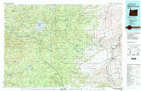 1983 Mount Hood1983 Print · USGSMount Hood and its surrounding national forest are captured here in the early eighties, spanning from alpine glaciers to the high desert plains. Genealogists and historians can trace old routes like the Barlow Road and locate remote landmarks like Bear Springs Ranger Sta or the settlement of Tygh Valley.
 - 1997 Map of Government Camp, 1999 Print
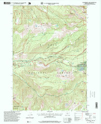 1997 Government Camp1999 Print · USGSGovernment Camp served as a bustling mountain outpost in the late nineties, positioned between two major wilderness areas. Researchers can trace the layout of the Ski Bowl and locate landmarks like the Zigzag East Lookout and Laurel Hill Quarry.
End of results
Showing maps 1-9 of 9
Frequently asked questions
- What are the different types of historical maps available for Government Camp?
- What is the oldest map of Government Camp?
- Where can I purchase historical maps of Government Camp for my home or office?
- Where can I download high-res historical maps of Government Camp?
- Are there historical topographic maps available for Government Camp?
- Is there historical aerial imagery available for Government Camp?
- Where are historical maps of Government Camp sourced from?