2020s Maps of Cannon Beach, Oregon
Explore 3 historic maps of Cannon Beach from the 2020s. These maps offer a rare glimpse into what life looked like during the 2020s — showing old roads, neighborhoods, homes, and landmarks that have changed or disappeared over time.
Whether you're researching your family's past, planning a metal detecting trip, or studying how Cannon Beach's landscape evolved across the 2020s, these high-resolution maps are a powerful tool for exploring the history of this region.
- Focus on a specific era: All maps on this page are from the 2020s, giving you a focused view of this time period.
- See what’s changed: Compare century-old streets, trails, and buildings to today's modern landscape using overlays and satellite layers.
- Research with precision: Use these maps for genealogy, historical research, land use analysis, or educational projects.
- View, download, or print: Maps are fully viewable online in high resolution, and can be downloaded or printed for your own records.
Start exploring Cannon Beach's history through authentic maps from the 2020s. This is your window into the past.
Cannon Beach, OR maps
(3)- 2020 Map of Arch Cape, 2020 Print
 2020 Arch Cape2020 Print · USGSCovers Cannon Beach, including Arch Cape, Clatsop County, and other nearby areas
 - 2024 Map of Tillamook Head, 2024 Print
 2024 Tillamook Head2024 Print · USGSThe Oregon coast at the onset of the 2020s shows a sophisticated mix of resort communities and protected wilderness. Local historians can trace the paths of Old US Hwy 101 or locate family plots at Evergreen Cem near the banks of Neawanna Creek.
 - 2024 Map of Arch Cape, 2024 Print
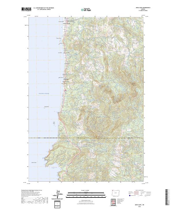 2024 Arch Cape2024 Print · USGSCoastal Oregon settlements and peaks are shown here in the 2020s as the Pacific shoreline meets the mountains. Researchers can trace landforms from Smuggler Cove to Onion Peak, alongside communities like Arch Cape and Cannon Beach.
End of results
Showing maps 1-3 of 3
Top cities near Cannon Beach
- Seaside historical maps
- Gearhart historical maps
- Manzanita historical maps
- Wheeler historical maps
- Nehalem historical maps
Top neighborhoods of Cannon Beach
Frequently asked questions
- What are the different types of historical maps available for Cannon Beach?
- What is the oldest map of Cannon Beach?
- Where can I purchase historical maps of Cannon Beach for my home or office?
- Where can I download high-res historical maps of Cannon Beach?
- Are there historical topographic maps available for Cannon Beach?
- Is there historical aerial imagery available for Cannon Beach?
- Where are historical maps of Cannon Beach sourced from?