1970s Maps of Bandon, Oregon
Explore 2 historic maps of Bandon from the 1970s. These maps offer a rare glimpse into what life looked like during the 1970s — showing old roads, neighborhoods, homes, and landmarks that have changed or disappeared over time.
Whether you're researching your family's past, planning a metal detecting trip, or studying how Bandon's landscape evolved across the 1970s, these high-resolution maps are a powerful tool for exploring the history of this region.
- Focus on a specific era: All maps on this page are from the 1970s, giving you a focused view of this time period.
- See what’s changed: Compare century-old streets, trails, and buildings to today's modern landscape using overlays and satellite layers.
- Research with precision: Use these maps for genealogy, historical research, land use analysis, or educational projects.
- View, download, or print: Maps are fully viewable online in high resolution, and can be downloaded or printed for your own records.
Start exploring Bandon's history through authentic maps from the 1970s. This is your window into the past.
Bandon, OR maps
(2)- 1970 Map of Bandon, 1973 Print
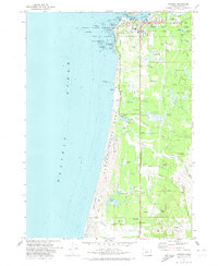 1970 Bandon1973 Print · USGSBandon and the Coos County coastline are captured here in the early seventies, a time when the local economy balanced maritime operations with extensive cranberry farming. Genealogists and local historians can locate the Knights of Pythias Cem, the Millard Sch, and family-named landmarks like Bradley Lake.2 unique versions available
 - 1970 Map of Bullards, 1973 Print
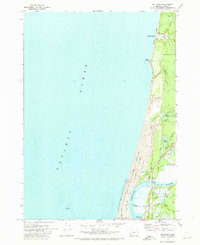 1970 Bullards1973 Print · USGSThe Oregon coast at the start of the 1970s reveals a unique landscape where the Coquille River winds past Cranberry Bogs and the small community of Bullards. Researchers can trace local landmarks like Bullards Cem, the Bullards Bridge, and the shifting Sand Dunes near Whisky Run.
End of results
Showing maps 1-2 of 2
Top cities near Bandon
Frequently asked questions
- What are the different types of historical maps available for Bandon?
- What is the oldest map of Bandon?
- Where can I purchase historical maps of Bandon for my home or office?
- Where can I download high-res historical maps of Bandon?
- Are there historical topographic maps available for Bandon?
- Is there historical aerial imagery available for Bandon?
- Where are historical maps of Bandon sourced from?