1990s Maps of Agness, Oregon
Explore 2 historic maps of Agness from the 1990s. These maps offer a rare glimpse into what life looked like during the 1990s — showing old roads, neighborhoods, homes, and landmarks that have changed or disappeared over time.
Whether you're researching your family's past, planning a metal detecting trip, or studying how Agness's landscape evolved across the 1990s, these high-resolution maps are a powerful tool for exploring the history of this region.
- Focus on a specific era: All maps on this page are from the 1990s, giving you a focused view of this time period.
- See what’s changed: Compare century-old streets, trails, and buildings to today's modern landscape using overlays and satellite layers.
- Research with precision: Use these maps for genealogy, historical research, land use analysis, or educational projects.
- View, download, or print: Maps are fully viewable online in high resolution, and can be downloaded or printed for your own records.
Start exploring Agness's history through authentic maps from the 1990s. This is your window into the past.
Agness, OR maps
(2)- 1992 Map of Port Orford, 1993 Print
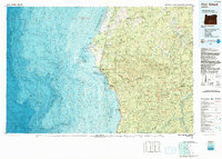 1992 Port Orford1993 Print · USGSThe southern Oregon coast and the coastal ranges of the early nineties are captured here in both topographic and bathymetric detail. Researchers can trace landforms from the reefs of Oregon Islands to inland landmarks like Bingham Mountain and Albert H Powers Memorial State Park.
 - 1998 Map of Agness, 2001 Print
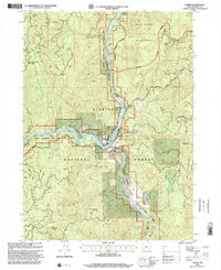 1998 Agness2001 Print · USGSThe confluence of the Rogue and Illinois Rivers defines this pocket of Curry County during the late nineties. Researchers can trace the riverfront settlement at Agness, including the Agness Cem, and map out numerous river landmarks like Arnold Riffle and Walker Bar.
End of results
Showing maps 1-2 of 2
Frequently asked questions
- What are the different types of historical maps available for Agness?
- What is the oldest map of Agness?
- Where can I purchase historical maps of Agness for my home or office?
- Where can I download high-res historical maps of Agness?
- Are there historical topographic maps available for Agness?
- Is there historical aerial imagery available for Agness?
- Where are historical maps of Agness sourced from?