1980s Maps of Reedsport, Oregon
Explore 3 historic maps of Reedsport from the 1980s. These maps offer a rare glimpse into what life looked like during the 1980s — showing old roads, neighborhoods, homes, and landmarks that have changed or disappeared over time.
Whether you're researching your family's past, planning a metal detecting trip, or studying how Reedsport's landscape evolved across the 1980s, these high-resolution maps are a powerful tool for exploring the history of this region.
- Focus on a specific era: All maps on this page are from the 1980s, giving you a focused view of this time period.
- See what’s changed: Compare century-old streets, trails, and buildings to today's modern landscape using overlays and satellite layers.
- Research with precision: Use these maps for genealogy, historical research, land use analysis, or educational projects.
- View, download, or print: Maps are fully viewable online in high resolution, and can be downloaded or printed for your own records.
Start exploring Reedsport's history through authentic maps from the 1980s. This is your window into the past.
Reedsport, OR maps
(3)- 1980 Map of Reedsport, 1987 Print
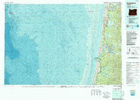 1980 Reedsport1987 Print · USGSThe Oregon coast at the dawn of the 1980s reveals a landscape defined by timber, tourism, and the shifting sands of the Oregon Dunes. Local historians can trace the rail-and-river economy through Reedsport, the historic timber town of Gardiner, and the lakeside community of Lakeside.
 - 1985 Map of Reedsport
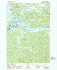 1985 Reedsport1985 Print · USGSThe riverfront towns of Reedsport and Gardiner are shown here in the mid-eighties, positioned at the confluence of the Smith and Umpqua Rivers. Local historians can trace industrial roots at the Paper Mill and Sawmill or locate landmarks like the Cem and Gardiner Reservoir.
 - 1985 Map of Winchester Bay
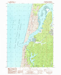 1985 Winchester Bay1985 Print · USGSThe Oregon coast in the mid-1980s reveals a landscape of shifting sands and busy harbors at the Umpqua River's mouth. Researchers can trace the development of Winchester Bay and its Salmon Harbor alongside landmarks like Barretts Landing and Lake Marie.
End of results
Showing maps 1-3 of 3
Top cities near Reedsport
Frequently asked questions
- What are the different types of historical maps available for Reedsport?
- What is the oldest map of Reedsport?
- Where can I purchase historical maps of Reedsport for my home or office?
- Where can I download high-res historical maps of Reedsport?
- Are there historical topographic maps available for Reedsport?
- Is there historical aerial imagery available for Reedsport?
- Where are historical maps of Reedsport sourced from?