Old Maps of Scottsburg, Oregon for Academic Research
Study the evolution of Scottsburg with 10 high-resolution historic maps. Whether you're teaching, researching, or modeling changes in land use, these maps provide essential visual documentation of urban, environmental, and geographic change.
- Analyze long-term change: Track patterns in development, transportation, and natural features.
- Ideal for environmental or urban studies: Support academic projects with primary historical map data.
- Use in the classroom or lab: Educators and researchers rely on these maps to bring historical context to life.
These maps are a powerful tool for teaching, research, and visualizing how Scottsburg has changed over the decades.
Scottsburg, OR maps
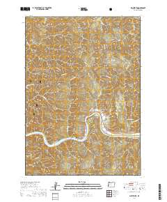
(10)- 1955 Map of Scottsburg, 1957 Print
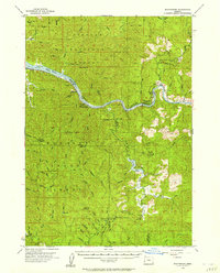 1955 Scottsburg1957 Print · USGSCoastal Oregon's timber and river country is recorded here in the mid-fifties, centered on the historic river landing of Scottsburg. Researchers can trace the early footprints of the Elliott State Forest and locate specific landmarks like Loon Lake, Ash Valley, and Elk Peak.3 unique versions available
 - 1958 Map of Roseburg, 1960 Print
 1958 Roseburg1960 Print · USGSThe timber valleys and high volcanic peaks of Southern Oregon are captured here in the late fifties. Researchers can trace the Southern Pacific rail line through historic settlements like Cottage Grove, Yoncalla, and Oakridge near the Cascade Range crest.4 unique versions available
 - 1959 Map of Roseburg
 1959 Roseburg1959 Print · USGSThe Umpqua and Willamette valleys meet the high Cascades in this late-fifties study of Southern Oregon's timber and rail corridors. Genealogists and researchers can trace the Southern Pacific RR through historic towns like Roseburg, Yoncalla, and Cottage Grove.
 - 1979 Map of Cottage Grove
 1979 Cottage Grove1979 Print · USGSThe Oregon timber and rail corridors of the late seventies are documented here, centered on the Coast Fork Willamette River and the growing hub of Cottage Grove. Researchers can trace the path of the Southern Pacific railroad as it connects small stations like Divide, Saginaw, and Yoncalla.2 unique versions available
 - 1985 Map of Scottsburg, 1986 Print
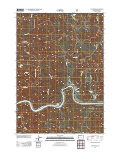
 1985 Scottsburg1986 Print · USGSThe Umpqua River valley in Douglas County remained a center for timber and river life in the mid-eighties. Genealogists and local historians can trace the foundations of Scottsburg, from the riverside Boat Ramp and Scottsburg Park to the Scottsburg Cem.
 - 2011 Map of Scottsburg, 2011 Print
 2011 Scottsburg2011 Print · USGSCovers Scottsburg, including Green Acres, Douglas County, and other nearby areas
 - 2014 Map of Scottsburg, 2014 Print
 2014 Scottsburg2014 Print · USGSCovers Scottsburg, including Green Acres, Douglas County, and other nearby areas
 - 2017 Map of Scottsburg, 2017 Print
 2017 Scottsburg2017 Print · USGSCovers Scottsburg, including Green Acres, Douglas County, and other nearby areas
 - 2020 Map of Scottsburg, 2020 Print
 2020 Scottsburg2020 Print · USGSCovers Scottsburg, including Green Acres, Douglas County, and other nearby areas
 - 2023 Map of Scottsburg, 2023 Print
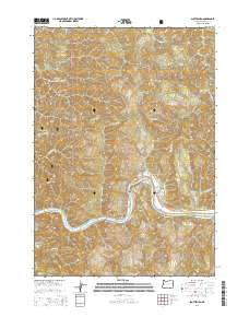
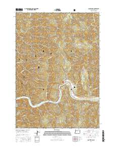
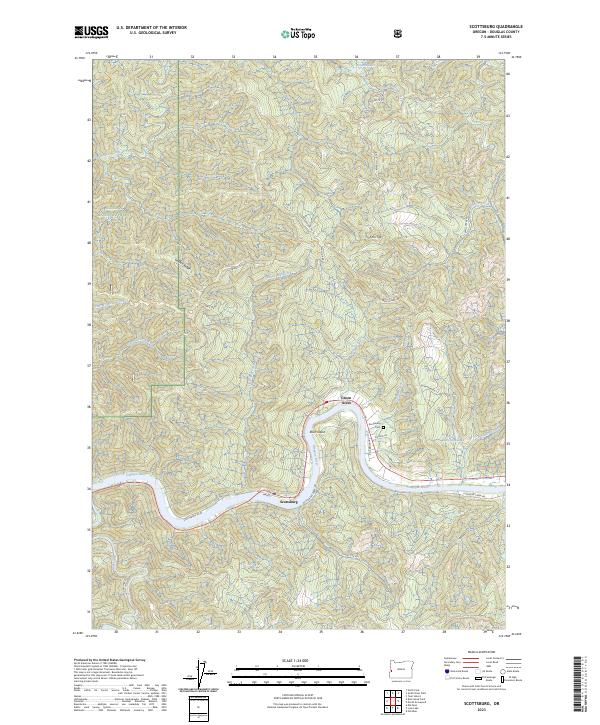 2023 Scottsburg2023 Print · USGSDouglas County’s riverfront comes into focus in this recent survey of the area where the coastal forests meet the water. Genealogists and local historians can locate the Scottsburg Cem and trace the development along the Umpqua River and Burchard Lake.
End of results
Showing maps 1-10 of 10
Frequently asked questions
- What are the different types of historical maps available for Scottsburg?
- What is the oldest map of Scottsburg?
- Where can I purchase historical maps of Scottsburg for my home or office?
- Where can I download high-res historical maps of Scottsburg?
- Are there historical topographic maps available for Scottsburg?
- Is there historical aerial imagery available for Scottsburg?
- Where are historical maps of Scottsburg sourced from?