1990s Maps of Monument, Oregon
Explore 2 historic maps of Monument from the 1990s. These maps offer a rare glimpse into what life looked like during the 1990s — showing old roads, neighborhoods, homes, and landmarks that have changed or disappeared over time.
Whether you're researching your family's past, planning a metal detecting trip, or studying how Monument's landscape evolved across the 1990s, these high-resolution maps are a powerful tool for exploring the history of this region.
- Focus on a specific era: All maps on this page are from the 1990s, giving you a focused view of this time period.
- See what’s changed: Compare century-old streets, trails, and buildings to today's modern landscape using overlays and satellite layers.
- Research with precision: Use these maps for genealogy, historical research, land use analysis, or educational projects.
- View, download, or print: Maps are fully viewable online in high resolution, and can be downloaded or printed for your own records.
Start exploring Monument's history through authentic maps from the 1990s. This is your window into the past.
Monument, OR maps
(2)- 1990 Map of Monument
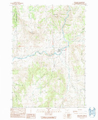 1990 Monument1990 Print · USGSMonument and the surrounding high-desert river valleys are captured here as they appeared in the 1990s. Researchers can trace the rural infrastructure of the North Fork John Day River and find landmarks like Hell Fire Flat and the Lookout Tower.
 - 1995 Map of Monument, 1998 Print
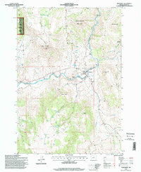 1995 Monument1998 Print · USGSThe community of Monument serves as the focal point of this mid-nineties survey of the John Day river country. Genealogists and historians can locate the local Cem, the small settlement at Graves, and mountain landmarks like Monument Mountain or Franklin Mountain.
End of results
Showing maps 1-2 of 2
Frequently asked questions
- What are the different types of historical maps available for Monument?
- What is the oldest map of Monument?
- Where can I purchase historical maps of Monument for my home or office?
- Where can I download high-res historical maps of Monument?
- Are there historical topographic maps available for Monument?
- Is there historical aerial imagery available for Monument?
- Where are historical maps of Monument sourced from?