1900s (20th Century) Maps of Seneca, Oregon
Explore 6 historic maps of Seneca from the 1900s (20th Century). These maps offer a rare glimpse into what life looked like during the 1900s — showing old roads, neighborhoods, homes, and landmarks that have changed or disappeared over time.
Whether you're researching your family's past, planning a metal detecting trip, or studying how Seneca's landscape evolved across the 1900s, these high-resolution maps are a powerful tool for exploring the history of this region.
- Focus on a specific era: All maps on this page are from the 1900s, giving you a focused view of this time period.
- See what’s changed: Compare century-old streets, trails, and buildings to today's modern landscape using overlays and satellite layers.
- Research with precision: Use these maps for genealogy, historical research, land use analysis, or educational projects.
- View, download, or print: Maps are fully viewable online in high resolution, and can be downloaded or printed for your own records.
Start exploring Seneca's history through authentic maps from the 1900s. This is your window into the past.
Seneca, OR maps
(6)- 1955 Map of Canyon City, 1966 Print
 1955 Canyon City1966 Print · USGSCentral Oregon's high desert and timber country are captured here in the mid-fifties, showing the rugged ranching and logging landscape. Trace the path of the Sumpter Valley Ry or locate remote settlements like Izee, Whitney, and Ritter.4 unique versions available
 - 1959 Map of Canyon City
 1959 Canyon City1959 Print · USGSEastern Oregon in the late fifties was a landscape of high timber and remote river valleys shaped by the cattle and mining trades. Genealogists and historians can trace the paths of the Sumpter Valley RR and find early settlements like Antone, Richmond, and Dayville.2 unique versions available
 - 1961 Map of Seneca, 1963 Print
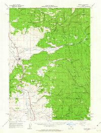 1961 Seneca1963 Print · USGSGrant County's timber and ranching country comes into focus in the early sixties, centered on the lumber town of Seneca. Genealogists and historians can trace family-named landmarks like Oliver Ranch and Charlie Smith Butte or the route of the Oregon Northwestern Railroad.2 unique versions available
 - 1978 Map of John Day, 1997 Print
 1978 John Day1997 Print · USGSEastern Oregon in the late 1970s shows a landscape defined by timber, mining, and high-desert hydrology. Researchers can trace the legacy of the Standard Mine, the route of the Oregon and Northwestern Railroad, and the remote outposts of Seneca and Prairie City.2 unique versions available
 - 1990 Map of Seneca
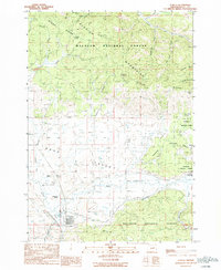 1990 Seneca1990 Print · USGSThe timber and ranching country of Grant County is captured here during the 1990s as the logging rail network began to fade. Researchers can trace the legacy of local families at Southworth Ranch and Southworth Cem or follow the Abandoned Railroad through Bear Valley.
 - 1998 Map of Seneca, 2000 Print
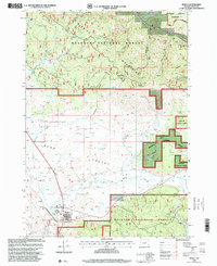 1998 Seneca2000 Print · USGSSeneca and the high Bear Valley are captured here during the late 1990s as they transition into the surrounding Malheur National Forest. Researchers can trace land use through features like the Southworth Cem, the Dry Soda Lookout, and the headwaters of the Silvies River.
End of results
Showing maps 1-6 of 6
Frequently asked questions
- What are the different types of historical maps available for Seneca?
- What is the oldest map of Seneca?
- Where can I purchase historical maps of Seneca for my home or office?
- Where can I download high-res historical maps of Seneca?
- Are there historical topographic maps available for Seneca?
- Is there historical aerial imagery available for Seneca?
- Where are historical maps of Seneca sourced from?