Old Maps of Silvies, Oregon
Explore 10 old maps of Silvies, spanning from 1955 to today. These high-resolution historic maps reveal how streets, neighborhoods, landmarks, and natural features evolved over time — perfect for genealogy, metal detecting, research, and local history exploration.
What you can do with these maps:
- See how Silvies changed over time: Compare historical maps to modern-day views to trace roads, homesites, rail lines & more.
- View detailed metadata: Each map includes creators, publishers, year, scale, and archive source.
- Overlay maps with satellite & LiDAR: Visualize the past alongside modern tools to explore terrain & human change.
- Trusted historical sources: Maps sourced from the USGS, Library of Congress, and other archives.
- Access maps your way: View online, download high-res files, or order prints for personal or research use.
Start exploring old maps of Silvies to uncover forgotten places, hidden landmarks, and the deep history beneath your feet.
Silvies, OR maps
(10)- 1955 Map of Canyon City, 1966 Print
 1955 Canyon City1966 Print · USGSCentral Oregon's high desert and timber country are captured here in the mid-fifties, showing the rugged ranching and logging landscape. Trace the path of the Sumpter Valley Ry or locate remote settlements like Izee, Whitney, and Ritter.4 unique versions available
 - 1959 Map of Canyon City
 1959 Canyon City1959 Print · USGSEastern Oregon in the late fifties was a landscape of high timber and remote river valleys shaped by the cattle and mining trades. Genealogists and historians can trace the paths of the Sumpter Valley RR and find early settlements like Antone, Richmond, and Dayville.2 unique versions available
 - 1961 Map of Seneca, 1963 Print
 1961 Seneca1963 Print · USGSGrant County's timber and ranching country comes into focus in the early sixties, centered on the lumber town of Seneca. Genealogists and historians can trace family-named landmarks like Oliver Ranch and Charlie Smith Butte or the route of the Oregon Northwestern Railroad.2 unique versions available
 - 1978 Map of John Day, 1997 Print
 1978 John Day1997 Print · USGSEastern Oregon in the late 1970s shows a landscape defined by timber, mining, and high-desert hydrology. Researchers can trace the legacy of the Standard Mine, the route of the Oregon and Northwestern Railroad, and the remote outposts of Seneca and Prairie City.2 unique versions available
 - 1990 Map of Silvies
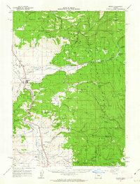
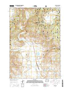
 1990 Silvies1990 Print · USGSThe Grant County ranching country and the Silvies River valley are captured here just before the turn of the millennium. Researchers can trace local heritage and land use through landmarks like Ponderosa Ranch, Silvies Landing, and the Maitland Landing Strip.
 - 1999 Map of Silvies, 2002 Print
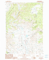
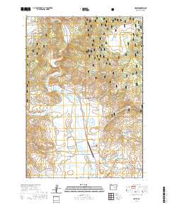
 1999 Silvies2002 Print · USGSGrant County ranching and timber lands are captured here at the close of the century, centered on the Silvies Valley and its lifeblood river. Genealogists and historians can trace the Ponderosa Ranch, locate the local Cem, or follow the path of the Bear Valley Burns road.
 - 2011 Map of Silvies, 2011 Print
 2011 Silvies2011 Print · USGSCovers Silvies, including Grant County, United States, and other nearby areas
 - 2014 Map of Silvies, 2014 Print
 2014 Silvies2014 Print · USGSCovers Silvies, including Grant County, United States, and other nearby areas
 - 2020 Map of Silvies, 2020 Print
 2020 Silvies2020 Print · USGSCovers Silvies, including Grant County, United States, and other nearby areas
 - 2024 Map of Silvies, 2024 Print
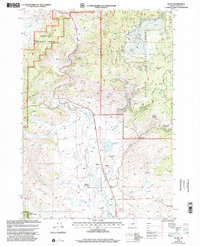
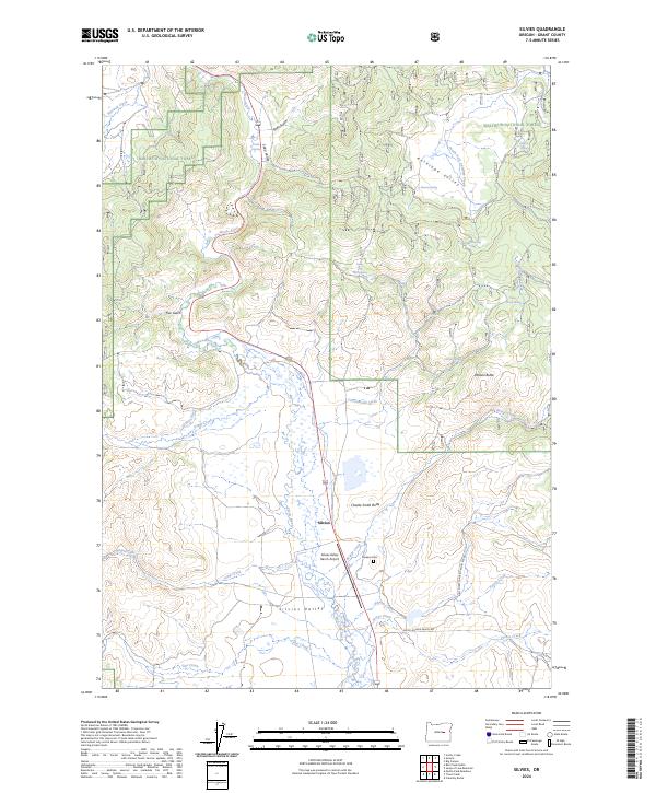 2024 Silvies2024 Print · USGSRanching and forestry define this Grant County landscape in the 2020s, centered on the historic Silvies Valley. Researchers can trace early family sites like Hankins Cem or explore the water network of Owens Ditch and the Silvies River.
End of results
Showing maps 1-10 of 10
Top cities near Silvies
Frequently asked questions
- What are the different types of historical maps available for Silvies?
- What is the oldest map of Silvies?
- Where can I purchase historical maps of Silvies for my home or office?
- Where can I download high-res historical maps of Silvies?
- Are there historical topographic maps available for Silvies?
- Is there historical aerial imagery available for Silvies?
- Where are historical maps of Silvies sourced from?