1990s Maps of Silvies, Oregon
Explore 2 historic maps of Silvies from the 1990s. These maps offer a rare glimpse into what life looked like during the 1990s — showing old roads, neighborhoods, homes, and landmarks that have changed or disappeared over time.
Whether you're researching your family's past, planning a metal detecting trip, or studying how Silvies's landscape evolved across the 1990s, these high-resolution maps are a powerful tool for exploring the history of this region.
- Focus on a specific era: All maps on this page are from the 1990s, giving you a focused view of this time period.
- See what’s changed: Compare century-old streets, trails, and buildings to today's modern landscape using overlays and satellite layers.
- Research with precision: Use these maps for genealogy, historical research, land use analysis, or educational projects.
- View, download, or print: Maps are fully viewable online in high resolution, and can be downloaded or printed for your own records.
Start exploring Silvies's history through authentic maps from the 1990s. This is your window into the past.
Silvies, OR maps
(2)- 1990 Map of Silvies
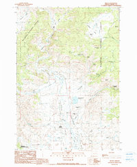 1990 Silvies1990 Print · USGSThe Grant County ranching country and the Silvies River valley are captured here just before the turn of the millennium. Researchers can trace local heritage and land use through landmarks like Ponderosa Ranch, Silvies Landing, and the Maitland Landing Strip.
 - 1999 Map of Silvies, 2002 Print
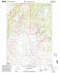 1999 Silvies2002 Print · USGSGrant County ranching and timber lands are captured here at the close of the century, centered on the Silvies Valley and its lifeblood river. Genealogists and historians can trace the Ponderosa Ranch, locate the local Cem, or follow the path of the Bear Valley Burns road.
End of results
Showing maps 1-2 of 2
Top cities near Silvies
Frequently asked questions
- What are the different types of historical maps available for Silvies?
- What is the oldest map of Silvies?
- Where can I purchase historical maps of Silvies for my home or office?
- Where can I download high-res historical maps of Silvies?
- Are there historical topographic maps available for Silvies?
- Is there historical aerial imagery available for Silvies?
- Where are historical maps of Silvies sourced from?