Old Maps of Frenchglen, Oregon for Hiking & Exploration
Hike through history with 7 historic maps of Frenchglen. Explore old trails, ghost towns, and forgotten backroads — perfect for outdoor adventurers and local explorers.
- Rediscover forgotten places: Map out old mining camps, roads, and footpaths that no longer exist on modern maps.
- Layer with modern tools: Combine with LiDAR or satellite views to plan hikes through historical terrain.
- Made for exploration: Popular among hikers, overlanders, and local history lovers.
Use these maps to find adventure and explore the hidden past of Frenchglen.
Frenchglen, OR maps
(7)- 1955 Map of Adel, 1971 Print
 1955 Adel1971 Print · USGSSoutheast Oregon in the mid-fifties remains a landscape of vast alkaline basins and high mountain scarps, anchored by remote outposts. Researchers can trace historic ranching routes through Catlow Valley and locate landmarks like Beatys Butte or the small settlement of Blitzen.2 unique versions available
 - 1957 Map of Adel
 1957 Adel1957 Print · USGSSoutheast Oregon in the mid-fifties reveals a high-desert landscape of sprawling ranches and vast wildlife refuges before modern development. Genealogists and researchers can trace the remote outposts of the region, from the Red Point School to historic headquarters like the Guano Ranch and Frenchglen.
 - 1958 Map of Adel
 1958 Adel1958 Print · USGSSoutheastern Oregon in the mid-fifties is captured here, showing a vast territory of high desert basins and isolated ranching outposts. Genealogists and researchers can trace the locations of the Red Point School, Frenchglen, and remote sites like Guano Ranch.2 unique versions available
 - 1962 Map of Adel, 1963 Print
 1962 Adel1963 Print · USGSSoutheastern Oregon in the early sixties reveals a landscape of massive basins, remote ranches, and expansive wildlife refuges. Researchers can locate vanished rural infrastructure like the Trout Creek School or trace early routes through Adel and Frenchglen.
 - 1967 Map of Frenchglen, 1972 Print
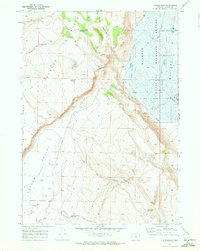 1967 Frenchglen1972 Print · USGSHarney County's high desert meets the wetlands of the Blitzen Valley in the late sixties, showing a landscape of remote ranching and conservation. Trace local history at Frenchglen and the P Ranch, or follow the Donner und Blitzen River into the Malheur National Wildlife Refuge.2 unique versions available
 - 1982 Map of Steens Mtn, 1983 Print
 1982 Steens Mtn1983 Print · USGSHarney County's high-desert landscape is captured here in the early 1980s, from the alpine heights of the fault-block Steens down to the alkali flats. Local historians can trace the isolated outpost at Frenchglen, the thermal Alvord Hot Springs, and the vast Malheur National Wildlife Refuge.2 unique versions available
 - 2024 Map of Frenchglen, 2024 Print
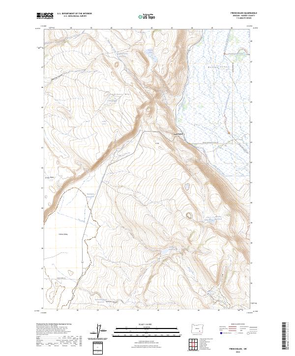 2024 Frenchglen2024 Print · USGSHarney County's high desert landscape meets the wetlands of the Blitzen Valley in this modern survey of the Frenchglen area. Researchers can trace remote water sources and land management via Griffith Spring Reservoir, Jackass Mtn, and the Donner und Blitzen River.
End of results
Showing maps 1-7 of 7
Frequently asked questions
- What are the different types of historical maps available for Frenchglen?
- What is the oldest map of Frenchglen?
- Where can I purchase historical maps of Frenchglen for my home or office?
- Where can I download high-res historical maps of Frenchglen?
- Are there historical topographic maps available for Frenchglen?
- Is there historical aerial imagery available for Frenchglen?
- Where are historical maps of Frenchglen sourced from?